Friday, February 29, 2008

Snow Through noon

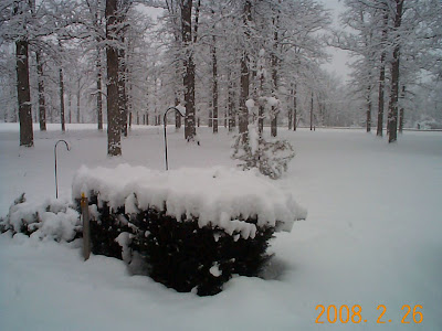
A very reflective band has set up some heavy snow. This is going to be short lived. It sure is pretty to look at though.

It looks like we are seeing another band of snow which is diving south this morning. So we could see another .50" to 1" accumulation.
We are still seeing snowfall north of Fort Wayne this morning. We have reports of about 1.6" of snow in Angola. To the west of Fort Wayne about 1" and in the city of Fort Wayne anywhere from .75" to an 1.5". We could see another quick inch of snow north before the low pulls away from the area later this morning.

Northern Stream System

A fast moving low is moving quickly towards the east this morning. Most areas are getting about 1 to 3 inches of snow with areas west and north of Fort Wayne receiving more.

This is 7am this morning with the low still not across the area yet. While most of energy is north still a decent amount of vorticity or spin across the area causing a good quick lift for some snow.

You can see this low has some cold air around it but not expansive enough to include northern Indiana.

Snow Ending Quickly

Snow from a northern stream system should be coming to a quick end this morning. There was a decent snow burst west of Fort Wayne, but it looks like most areas saw an inch or less of snowfall this morning.

Thursday, February 28, 2008

Huge Thunderstorm From Space!

Joesph Miller sends this picture of a huge thunderstorm. This thunderstorm picture was taken from the International Space Station. Here is the text about the picture: "On February 5Th, 2008 the International Space Station flew over the country of Mali - located in West Africa. One of the astronauts snapped this photo of a very large thunderstorm. Please note the huge anvil shape at the top of this thunderstorm, along with the overshooting tops where the best lift in this particular thunderstorm was occurring at the time the picture was taken."


This picture first appeared on the blog Dvorak Uncensensored

Northern Stream System

All Winter we've been discussing the northern and southern jet stream patterns and how those 'phased' or came together for this last big storm system. Tonight and tomorrow we will not see that phasing but we will still see some snow shower activity.

While the energy for this system stays north there is enough lift south to cause some snow showers. This will be a different kind of snow, more of a light fluffy snowfall because of the colder temperatures.

Wednesday, February 27, 2008

Snow kangaroo


This e-mail and photos were sent to NewsChannel 15: Hi, my name is Aubrey Schaffer, and with the help of my friend Reid Marquart, we built a 7 1/2ft. tall snow Kangaroo. It took about 3 hours to construct, and we had a lot of fun doing it.
We've both lived here in Fort Wayne our whole lives, and by now we know how to have fun outside in the winter here in Indiana. We watch news channel 15 nightly, and we think our snow kangaroo takes the cake! We hope you enjoy our pictures

Friday Forecast

Winter is certainly not through with us. Take a look at Friday. Another Northern system makes it way through our area. I wish I could really excited about this northern stream system but low pressure is staying along the northern stream and is really only going to make a minimal impact in our area.
Here is the European model with the low just north of the Dakotas by 7pm Thursday.There the system progresses Friday morning. Still well north of the area. The European has a track a little farther north. But I think we can say this system is not going to have a big impact on the area.
Finally here is the system by midday on Friday. Still not really take a southerly track.

8 Foot Snowman


From WANE.com: Some Fort Wayne residents made an 8 foot tall snowman from the Winter storm that hit on Monday, Februrary 25. The snowman is located at 1066 Shore Drive and it was made by Charlie Cochran, Abe Wedler and Brice Stevenson.

A Quiet but cold day

Even though things for the most part will be quiet we will see a very strong northerly flow from the arctic circle. Because this cold air is traveling over snow fields it will not modify much. The core of the coldest air is still to the north but we still see -18C across the area this morning. Temperatures will not go up much at all today either.
Thursday moring will still see the -20C line across the area at 850 mb.

Tuesday, February 26, 2008

Some Snow Pictures

Gerry Shidler from Paulding, Ohio sends these pictures my way. He says Paulding had about 8" of snowfall.

Finally it's over


The low tracked farther north and west this afternoon that's been the MO all year long for these weather systems. Indianapolis ended up with nothing and it looks like the bulk of the snow was from Fort Wayne north. There is an area of snow west of us, but it continues to break apart and should be nothing like what we just saw. Lake effect snowfall may be a problem, but right now winds have stayed under 10 mph. Unless winds increase lake effect will not be a problem for the rest of the day.

Snowfall Totals

Here is a list of current snowfall totals from our website wane.com I will continue to update them throughout the day.

Doppler Radars


Snowfall Overnight

The snowfall overnight has left many areas with up to about 6 inches of snowfall. It looks like the it was all snow last night. So much for the rain/sleet/snow mix. Many observations reported snowflakes as big as silver dollars last night. One part of the system I did get correct yesterday was the fact that the heaviest snowfall was northwest of the Fort Wayne area. It also is a very wet heavy snowfall as temperatures hovered around 32 degrees all night long. We are also seeing that trowal effect I was referring to yesterday across northwestern Ohio where snow has changed to rain.
Here is the main low pressure area is moving due east through Kentucky. We will still see snow but the heaviest precipitation will be south of the area.
By 1pm the low pulls across southern Ohio. Really taking any heavy snowfall away from our area.
By 7pm the low is no longer a factor. However, there seems to be some lake effect snow bands setting up.

I wanted to show you one more look at what's happening this morning. There is a 500mb or upper level low across the area with a tongue of warm moist air and some areas getting rain this morning.

Monday, February 25, 2008

Winter Storm Warning

A Winter Storm Warning has been issued for the area. While I agree there is potential for heavy snow in our area it still looks like the heaviest snowfall will be south of Fort Wayne. Read post below

Staying South

The 6z (1am) Global Forecast Model is bringing a little more certainty to the developing Winter storm. It has the main low pressure are staying south. Here is the 6z Tuesday 1am tomorrow. (Click on it to make it bigger) The low moves across the southern part of Illinois. This is about 50 to 75 miles farther south than the previous model run. Also notice the temperature at 850mb is about 33 degrees. So we are right at freezing here, We could begin seeing a heavy wet snow across the area.
By 12z or 7am tomorrow morning the low moves across the southern Indiana. The direct east to west movement may mean more snow for areas south of Fort Wayne. This puts the heaviest snowfall south of Fort Wayne to just north of Indianapolis. This could be heavier snow for folks in Muncie. What we are looking for here is a northeast movement of the low towards Toledo.
By 18Z Tuesday we begin to see a really definitive pattern for this system taking it to the east coast.

A couple of things to keep in mind here. This model has been really inconsistent this year. Usually taking the snow track more toward the north and the west. If this were to occur then heavy snow would be a possibility for the area. However, this model run today shows consistency with the model of choice that I use most often, (the European). The European has a similar track for this storm system the last several runs. So, in meteorology we can't draw foregone conclusions but this seems to be more of a certainty in path for this weather system.

Just put a 'TROWAL' in it

To add to the post below and another little complication that we have seen just a couple of weeks ago. This is called a trowal. A trowal or tongue of warm air in the upper atmosphere which could give the area more rain then snow! This would really knock snowfall totals down.

Now the fun begins!

So if you woke up and looked at any weather website you see the watches have already gone out for this Winter storm which doesn't develop until overnight tonight and into tomorrow across our area. In my opinion let's not throw up the red flag yet. Temperatures are one hurdle we have to get over the other is what I blogged about yesterday the dreaded track of the low pressure. Let's deal with temperatures first it looks like temperatures don't drop to 32.2F until about 4am. It will be a rain/snow mix from about 10pm until 4am when the change over occurs. Right now the NAM-Cobb output is about 6.1". My best estimate is to cut that in half, at best this model is overdone on this system. (This has been the case this year and this model has seriously overdone every storm system). The other variable here is your model choice. Let's take a look at a few:
Here is the European with the low at 7am this morning across northern Oklahoma. Right now Omaha is getting rain from this system.
The system on this model dives south across southern Indiana with 850mb temperatures of -2 by 7am Tuesday. This track would take the low slowly toward the northeast but not fast enough. My big fear here is that we don't change over to snowfall quickly enough and end up with no measurable snowfall

Here is the GFS at 7pm tonight with the low across the 'boot hill' of Missouri
We move to 6z or about 1am Tuesday morning. The low moves across southern Illinois and just south of Terre Haute. Note that the temperatures on this model are Fahrenheit and just hovering above zero.
The low moves almost straight across the area and is in Cincinnati by 7am Tuesday.
By 1pm still looking at snowfall with some snow on the back side of the weather system.

Danger alert here. If this system tracks northwest we could see all rain in places like Fort Wayne and heavy snow to the north.

Sunday, February 24, 2008

This is going to be a close call

Let's talk about the certainties of this next weather system on Monday and Tuesday. We know it is going to be considerably colder. By 00z Wednesday (7pm Tuesday) Temperatures drop to -14C at 850mb. The cold air advection continues into Wednesday as 850mb temperatures drop to -18c by the end of the day. Hint: It doesn't look like a lot of warming Wednesday. We also know we will see snow, but how much. That of course is the one-hundred dollar question! You may know by reading this blog that precipitation and precipitation amounts are one of the most difficult calls to make. One of the most difficult things to do is to pinpoint where the snow is going to fall. Many times we are correct on the amount of snow that will fall but the track changes and the snow ends up 50 miles away. Right now the NAM-Cobb output has us at about 2.5" of snow. I think this is good call to begin with as I really don't like the track of this system. It's too far north for my taste right now for a heavy snowfall. I'll show you a couple of examples here: The placement of the low here is about 100 miles too far north if you follow it I think it moves through just north of Indianapolis That's a lot of sleet for our area and diminishes the snowfall totals.
The east coast better watch out this has nor easter' and 'bombogenesis' written all over it!


I like the track on this model a little better. This is the GFS it has the low about 50 to 75 miles south of the above track on the European.
This is the 54 hour GFS which has the system crossing southern Illinois and going through Terre Haute.
This is the final graphic where the system phases across the east coast and makes a huge storm.

This storm also phases with the northern jet stream across Missouri so that makes it more interesting for us as far as energy and snowfall. Here's the 'fly in the ointment' for me. The first model that I've shown above (European) has been more consistent and is certainly the model of choice here. That would indicate a small snowfall of 2 to 3 inches. The National Weather Service has already considered one their famous 48 hour ahead time watches. I am so glad they did not issue it here because it saves me headaches today and tomorrow I really think it's too early to issue anything on this storm as it's still out in the Pacific. We'll have fun following it though!

Friday, February 22, 2008

Radar Loop

Here comes the system snow


Here's a look at the latest radar with the shield of snow coming from low pressure which is just south of the state. You can see that the northern side of this snow shield is not making any farther north than Marion. I expect a snow burst for Marion and Kokomo early this afternoon and then the low will pull everything with it to the east very quickly by late this afternoon.


You can see the low placement is significantly south and not a factor for northern Indiana by 00Z tonight.

Some Snow...But not a big deal

Last night we saw the warm air advection which kind of marked the beginning of a more substantial vort lobe to the south. The southern system will move through southern Illinois today. I have a difficult time believing that we'll get more then an inch out of this weather system, even down to the south of Fort Wayne where there is still a winter weather advisory in effect until 7pm. Here in lies the problem, even though these southern counties will not meet the warning critera the NWS can not flip-flop and back off the thing so we are stuck with a bad advisory that I have to talk about and discount all morning long. (Grumble, grumble...)
Look reallyl closely here. The low is moving through central Kentucky and continues due east. Not really a northeastern tendancy here.
By 7pm tonight it's really over as the low is on the east coast.
Here is an estimated snowfall graphic bringing the heaviest snow between Muncie and Indianapolis.

Thursday, February 21, 2008

Almost Over...At least for tonight

The snow is coming to a quick end. We may get another burst of snow during the early morning hours but it looks like accumulations will be light. There is a winter weather advisory to the south of Fort Wayne, but I think that is way over done. The actual system will be well to the south and will not track north so snow on the back side of the low, like we saw last week will not be possible.

Snow Kidding!

Yes it's snowing. Current compsite radar has the snow pretty solid across northern Indiana. It looks like the snow continues for about the next 3 to 4 hours with up to 2 inches possible. Remember this is the snow actually ahead of the system. The system snow really is not going to be in our area, so this is really it.


Snow in State


Take a look at the latest composite radar. Snow is entering the state. This is ahead of the main system which is still several states to our south. This first surge of snowfall is from the warm front and as the warm as begins it's northward motion we may see some snow showers later this afternoon. Then it looks like the warm air will stay in the middle layers of the atmosphere and we could see some sleet or freezing drizzle this evening as well.

More on Friday Storm

The models are beginning to come into some sort of agreement here. Even though the QPF is still going with snowfall of over 3 inches I think that most if not all moisture will be in the south. Here's the latest runs.
The normally wet ETA/NAM/WRF has all of the mositure from southern to central Indiana. Could see some ice accumulation.
Here's the latest European model. It has the low even farther to the south. I think we can say now with even more certainty that the storm will be south.