Wednesday, April 30, 2008
Frustration with forecasts
One thing that never ceases to get my hackles up is when I get a viewer call, usually from an older person, who tells me that my forecast and the forecast on the weather channel don't agree. I've gone through here why it is a good probability that our forecasts will not agree, but I will give a short diatribe on this philosophy. Forecast models are based on mathematical problems and solutions. These 'models' are run on the fastest computers in the world which figure billions of problems and solutions a minute. The weather channel has their own model which is based on many grid points. However, in many areas these grid points are few and far between. Anyone who has lived here for any length of time knows that the weather is much different in the South Bend and Indianapolis areas, yet the weather channel 'scientists' fail to account for this and their models calculate large areas with single grid points. These forecasts are easily found throughout the Internet, television and even on local radio broadcasts. To be fair it's not just the Weather Channel doing this but Internet forecasts can be very unreliable and certainly frustrating to those of us who actually have our own forecasting methods. Oh well, off the rant for right now but I sure would like to hear your comments on this issue.
Tuesday, April 29, 2008
New Climate measuring stations
Okay so I'm lazy today and not posting my own content but I found this interesting as well:
NOAA Employing New Tools to Accurately Measure Climate Change
April 24, 2008
High Resolution (Credit: NOAA)
NOAA today announced it will install the last nine of the 114 stations as part of its new, high-tech climate monitoring network. The stations track national average changes in temperature and precipitation trends. The U.S. Climate Reference Network (CRN) is on schedule to activate these final stations by the end of the summer.
NOAA also is modernizing 1,000 stations in the Historical Climatology Network (HCN), a regional system of ground-based observing sites that collect climate, weather and water measurements. NOAA’s goal is to have both networks work in tandem to feed consistently accurate, high-quality data to scientists studying climate trends.
Climate Reference Network - Making a Difference
The CRN is helping to pinpoint the shifts in America’s changing, often unpredictable, climate. “We’re entering a new age of understanding climate change, by adding more sound, reliable data about what’s really happening in the atmosphere and on the ground,” said Dr. Tom Karl, director of NOAA’s National Climatic Data Center in Asheville, N.C. Karl, one of the world’s leading experts on climate change, helped spearhead the new climate network’s development.
“Very high accuracy in the data collected is the key to getting a feel for the national trend. That’s what the Climate Reference Network is doing.”
CRN station in Baker, Nev.
High Resolution (Credit: NOAA)
Karl said the placement of each CRN station is crucial to obtaining accurate information on current — and likely future — conditions. “All the stations are strategically placed in rural environments away from the influences of nearby urban areas that would confound the interpretation of any changes observed,” he said.
Each CRN station logs real-time measurements of surface temperature, precipitation, wind speed and solar radiation. NOAA’s geostationary satellites relay the data from these ground-based stations to NCDC, which posts the observations online.
Historical Climatology Network - Modernization Underway
The modernization of the HCN’s aging equipment will enhance the extent of America’s premiere data source for tracking regional climate variations and trends. The modernization, which began November 2006, will follow a “climate-region” approach, starting with a pilot project in the Southwest, where 140 sites will be revamped. HCN sites will be equipped with a new temperature and precipitation sensor that will complement the CRN, with precise regional climate data.
Data gathered by those existing HCN stations that were located in less-than-ideal areas have been statistically corrected in the analysis of climate trends routinely reported by NOAA. Though some individual stations were placed in less-than-ideal areas, these data anomalies did not significantly alter overall climate measurements. The modernization will relocate these stations in areas that are closer to ideal.
In one critical example, this dense, spatial coverage will provide more timely and accurate regional data to support the National Integrated Drought Information System, a collaboration among federal agencies and several state governments geared to provide a dynamic and accessible drought-risk information system.
“Monitoring and understanding climate is a long-term endeavor. We need to have updated systems, such as the Historical Climatology Network, in place for the long haul,” said David Caldwell, director of the Office of Climate, Water and Weather Services at NOAA’s National Weather Service in Silver Spring, Md.
Caldwell added that a modernized HCN will give NOAA scientists more information to “help explain what’s happening with the climate at the regional and local level and serve as a baseline for evaluating other meteorological data.”
Storm brewing for William Gray Hurricane forecaster says his dispute with school focuses on global warming debate
By ERIC BERGERCopyright 2008 Houston Chronicle

By pioneering the science of seasonal hurricane forecasting and teaching 70 graduate students who now populate the National Hurricane Center and other research outposts, William Gray turned a city far from the stormy seas into a hurricane research mecca.
But now the institution in Fort Collins, Colo., where he has worked for nearly half a century, has told Gray it may end its support of his seasonal forecasting.
As he enters his 25th year of predicting hurricane season activity, Colorado State University officials say handling media inquiries related to Gray's forecasting requires too much time and detracts from efforts to promote other professors' work.
But Gray, a highly visible and sometimes acerbic skeptic of climate change, says that's a "flimsy excuse" for the real motivation — a desire to push him aside because of his global warming criticism.
Among other comments, Gray has said global warming scientists are "brainwashing our children."
Now an emeritus professor, Gray declined to comment on the university's possible termination of promotional support.
But a memo he wrote last year, after CSU officials informed him that media relations would no longer promote his forecasts after 2008, reveals his views:
"This is obviously a flimsy excuse and seems to me to be a cover for the Department's capitulation to the desires of some (in their own interest) who want to reign (sic) in my global warming and global warming-hurricane criticisms," Gray wrote to Dick Johnson, head of CSU's Department of Atmospheric Sciences, and others.
The university may have moderated its stance since last year. Officials said late last week that they intend to support the release of Gray's forecasts as long as they continue to be co-authored by Phil Klotzbach, a former student of Gray's who earned his doctorate last summer, and as long as Klotzbach remains at CSU.
When Klotzbach leaves, he will either produce the seasonal forecasts at his new position, or end them altogether.
Not only does this internal dispute reveal a bit of acrimony at the end of Gray's long career at CSU; it highlights the politically charged atmosphere that surrounds global warming in the United States.
"Bill Gray has come under a lot of fire for his views," said Channel 11 meteorologist Neil Frank, a former director of the National Hurricane Center and a friend of Gray's. "If, indeed, this is happening, it would be really sad that Colorado State is trying to rein in Bill Gray."
CSU officials insist that is not the case.
The dean of the College of Engineering, which oversees atmospheric sciences, said she spoke with Gray about terminating media support for his forecasts solely because of the strain it placed on the college's sole media staffer.
"It really has nothing to do with his stand on global warming," said the dean, Sandra Woods. "He's a great faculty member. He's an institution at CSU."
According to Woods, Gray's forecasts require about 10 percent of the time a media support staff member, Emily Wilmsen, has available for the College of Engineering and its 104 faculty members.
A professor of public relations at Boston University, Donald Wright, questioned why the university would want to pull back its support for Gray now, after he has published his forecasts for a quarter-century.
"It's seems peculiar that this is happening now," Wright said. "Given the national reputation that these reports have, you would think the university would want to continue to promote these forecasts."
Gray, he said, seems to deliver a lot of publicity bang for the buck. The seasonal forecasts are printed in newspapers around the country and splashed across the World Wide Web.
There also seems to be little question that prominent climate scientists have complained to CSU about Gray's vocal skepticism. The head of CSU's Department of Atmospheric Sciences, Dick Johnson, said he has received many comments during recent years about Gray — some supportive, and some not.
The complaints have come as Gray became increasingly involved in the global warming debate. His comments toward adversaries often are biting and adversarial.
In 2005, when Georgia Tech scientist Peter Webster co-authored a paper suggesting global warming had caused a spike in major hurricanes, Gray labeled him and others "medicine men" who were misleading the public.
Webster, in an e-mail from Bangladesh, where is working on a flood prediction project, acknowledged that he complained to Johnson at CSU.
"My only conversation with Dick Johnson, which followed a rather nasty series of jabs from Gray, suggested that Bill should be persuaded to lay off the personal and stay scientific," Webster wrote.
Gray also has been highly critical of a former student, Greg Holland, who is among the most visible U.S. scientists arguing about the dangers posed by global warming.
Gray's comments about Holland include referring to him as a member of a "Gang of Five" that is interested in using scare tactics to increase research funding.
The comment was a reference to the Gang of Four, which terrorized China in the 1960s and '70s while purging the Communist Party of moderates and intellectuals.
"I have registered concern in several quarters, including CSU, on the manner in which he has moved away from scientific debate and into personal attacks on the integrity and motives of myself and my colleagues," Holland said.
Although he ceded lead authorship of the forecasts to Klotzbach in 2006, Gray has remained the headliner in storm prognostication. He annually is among the most popular draws at the National Hurricane Conference.
In recent years, as he has increasingly made sharp public comments about global warming, Gray quickly became one of the most prominent skeptics because of his long background in atmospheric sciences.
His views on the climate — he says Earth is warming naturally and soon will begin cooling — have been applauded by some scientists, particularly meteorologists such as Frank. But they are out of step with mainstream climate science.
The most recent report by an international group of climate scientists, the Intergovernmental Panel of Climate Change, concluded that there was 90 percent certainty that human activity had caused recent warming of the planet.
Yet at U.S. universities, threats to the rights of scientists who hold minority viewpoints are generally frowned upon.
A prominent legal scholar, Stanley Fish of Florida International University, said university public relations offices should not pick and choose where resources go, based upon the content of a professor's work.
"If it can in any way be established that (Gray's) global warming views were the basis of this action, then it is an improper action," Fish said.
In his memo, Gray clearly indicates that he believes his academic freedom is imperiled:
"For the good of all of us in the Department, the College and at CSU, please believe me when I say this is not a direction any of you want to go," he wrote. "Our department and college are strong enough to be able to tolerate a dissenting voice on the global warming question."
Woods, Gray's dean, insisted that dissent on global warming is welcomed at CSU.
"He's not the only faculty member in the world who questions global warming," Woods said. "When Bill talks about some of the data, he can make some very good points."
By ERIC BERGERCopyright 2008 Houston Chronicle
By pioneering the science of seasonal hurricane forecasting and teaching 70 graduate students who now populate the National Hurricane Center and other research outposts, William Gray turned a city far from the stormy seas into a hurricane research mecca.
But now the institution in Fort Collins, Colo., where he has worked for nearly half a century, has told Gray it may end its support of his seasonal forecasting.
As he enters his 25th year of predicting hurricane season activity, Colorado State University officials say handling media inquiries related to Gray's forecasting requires too much time and detracts from efforts to promote other professors' work.
But Gray, a highly visible and sometimes acerbic skeptic of climate change, says that's a "flimsy excuse" for the real motivation — a desire to push him aside because of his global warming criticism.
Among other comments, Gray has said global warming scientists are "brainwashing our children."
Now an emeritus professor, Gray declined to comment on the university's possible termination of promotional support.
But a memo he wrote last year, after CSU officials informed him that media relations would no longer promote his forecasts after 2008, reveals his views:
"This is obviously a flimsy excuse and seems to me to be a cover for the Department's capitulation to the desires of some (in their own interest) who want to reign (sic) in my global warming and global warming-hurricane criticisms," Gray wrote to Dick Johnson, head of CSU's Department of Atmospheric Sciences, and others.
The university may have moderated its stance since last year. Officials said late last week that they intend to support the release of Gray's forecasts as long as they continue to be co-authored by Phil Klotzbach, a former student of Gray's who earned his doctorate last summer, and as long as Klotzbach remains at CSU.
When Klotzbach leaves, he will either produce the seasonal forecasts at his new position, or end them altogether.
Not only does this internal dispute reveal a bit of acrimony at the end of Gray's long career at CSU; it highlights the politically charged atmosphere that surrounds global warming in the United States.
"Bill Gray has come under a lot of fire for his views," said Channel 11 meteorologist Neil Frank, a former director of the National Hurricane Center and a friend of Gray's. "If, indeed, this is happening, it would be really sad that Colorado State is trying to rein in Bill Gray."
CSU officials insist that is not the case.
The dean of the College of Engineering, which oversees atmospheric sciences, said she spoke with Gray about terminating media support for his forecasts solely because of the strain it placed on the college's sole media staffer.
"It really has nothing to do with his stand on global warming," said the dean, Sandra Woods. "He's a great faculty member. He's an institution at CSU."
According to Woods, Gray's forecasts require about 10 percent of the time a media support staff member, Emily Wilmsen, has available for the College of Engineering and its 104 faculty members.
A professor of public relations at Boston University, Donald Wright, questioned why the university would want to pull back its support for Gray now, after he has published his forecasts for a quarter-century.
"It's seems peculiar that this is happening now," Wright said. "Given the national reputation that these reports have, you would think the university would want to continue to promote these forecasts."
Gray, he said, seems to deliver a lot of publicity bang for the buck. The seasonal forecasts are printed in newspapers around the country and splashed across the World Wide Web.
There also seems to be little question that prominent climate scientists have complained to CSU about Gray's vocal skepticism. The head of CSU's Department of Atmospheric Sciences, Dick Johnson, said he has received many comments during recent years about Gray — some supportive, and some not.
The complaints have come as Gray became increasingly involved in the global warming debate. His comments toward adversaries often are biting and adversarial.
In 2005, when Georgia Tech scientist Peter Webster co-authored a paper suggesting global warming had caused a spike in major hurricanes, Gray labeled him and others "medicine men" who were misleading the public.
Webster, in an e-mail from Bangladesh, where is working on a flood prediction project, acknowledged that he complained to Johnson at CSU.
"My only conversation with Dick Johnson, which followed a rather nasty series of jabs from Gray, suggested that Bill should be persuaded to lay off the personal and stay scientific," Webster wrote.
Gray also has been highly critical of a former student, Greg Holland, who is among the most visible U.S. scientists arguing about the dangers posed by global warming.
Gray's comments about Holland include referring to him as a member of a "Gang of Five" that is interested in using scare tactics to increase research funding.
The comment was a reference to the Gang of Four, which terrorized China in the 1960s and '70s while purging the Communist Party of moderates and intellectuals.
"I have registered concern in several quarters, including CSU, on the manner in which he has moved away from scientific debate and into personal attacks on the integrity and motives of myself and my colleagues," Holland said.
Although he ceded lead authorship of the forecasts to Klotzbach in 2006, Gray has remained the headliner in storm prognostication. He annually is among the most popular draws at the National Hurricane Conference.
In recent years, as he has increasingly made sharp public comments about global warming, Gray quickly became one of the most prominent skeptics because of his long background in atmospheric sciences.
His views on the climate — he says Earth is warming naturally and soon will begin cooling — have been applauded by some scientists, particularly meteorologists such as Frank. But they are out of step with mainstream climate science.
The most recent report by an international group of climate scientists, the Intergovernmental Panel of Climate Change, concluded that there was 90 percent certainty that human activity had caused recent warming of the planet.
Yet at U.S. universities, threats to the rights of scientists who hold minority viewpoints are generally frowned upon.
A prominent legal scholar, Stanley Fish of Florida International University, said university public relations offices should not pick and choose where resources go, based upon the content of a professor's work.
"If it can in any way be established that (Gray's) global warming views were the basis of this action, then it is an improper action," Fish said.
In his memo, Gray clearly indicates that he believes his academic freedom is imperiled:
"For the good of all of us in the Department, the College and at CSU, please believe me when I say this is not a direction any of you want to go," he wrote. "Our department and college are strong enough to be able to tolerate a dissenting voice on the global warming question."
Woods, Gray's dean, insisted that dissent on global warming is welcomed at CSU.
"He's not the only faculty member in the world who questions global warming," Woods said. "When Bill talks about some of the data, he can make some very good points."
Cold Overnight Temperatures!
Freeze Watch IN Effect From This Evening Through Wednesday Morning... The National Weather Service IN Northern Indiana Has Issued A Freeze Watch...Which Is IN Effect From This Evening Through Wednesday Morning. Temperatures May Fall Below Freezing Tonight...For A Period Long Enough To Damage Sensitive Plants. Otherwise...Areas Of Frost Are Expected. A Freeze Watch Means Sub-Freezing Temperatures Are Possible. These Conditions Could Kill Crops And Other Sensitive Vegetation.
Monday, April 28, 2008
Cool start to the week
Talk about a cool down. It looks like the main low has moved through our area and we are looking at a secondary low coming today and even early tomorrow.
 Here is the secondary front in today you can see the shield of precipitation around this as it pulls down cooler air out of the north.
 At 1:00 am it doesn't change much early tomorrow as a trough in the upper atmosphere still spinning around. Many times, especially during the winter and early spring we see the upper trough lagging behind the surface system.
 A repeat performance tomorrow morning, although it looks like high pressure will begin to clear things out by late morning and early afternoon.
Moon Dogs!
Feel like howling at the moon? This is really cool stuff, I have to admit that I've never seen a "moon dog". From Space.com
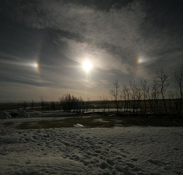
MOON HALOES: When moonlight shines through icy clouds, the usual result is a simple pair of moondogs. But recently near Mt. Hekla, Iceland, photographer Agust Gudmundsson saw much more:
"It was a spectacular night," says Gudmundsson who needed two pictures to encompass the full display: #1, #2. "I don't know the names of all the optics in the photos, but they were fantastic."
Atmospheric optics expert Les Cowley identifies them for us: "This truly beautiful display has everything. A lunar parhelic circle courses through the moon and its dog companions. There is a 22 degree halo topped by an upper tangent arc. Higher still there is a rare lunar circumzenithal arc and something seen even less often: a lunar supralateral arc." For a quick-look summary, click here.
"In one of the photos, there is a hole in the snow," notes Gudmundsson. "It is a snowhouse where my son Atli age 12 slept this amazing night!" Can you find it?
Solar Flares
Space weather anyone? How about some solar flares?
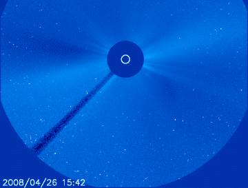
SOLAR BLAST: No sunspots? No problem. On April 26th the blank sun unleashed a solar flare without the usual aid of a sunspot. At 1408 UT, Earth-orbiting satellites detected a surge of X-rays registering B3.8 on the Richter scale of solar flares. Shortly thereafter, SOHO coronagraphs recorded a coronal mass ejection (CME) billowing away from the sun:
The expanding cloud could deliver a glancing blow to Earth's magnetic field late on April 28th or 29th. High-latitude sky watchers should be alert for auroras when it arrives.
This strange solar flare came from a patch of sun (N08,E08) where magnetic fields were not intense enough to form a visible sunspot (sunspots are made of magnetism). Nevertheless, magnetic fields were present with sufficient energy and instability to produce a powerful explosion. NASA's twin STEREO spacecraft, observing the sun from widely separated vantage points, recorded a million mph shock wave or "solar tsunami" spreading from the blast site through the sun's atmosphere: movie.
Not bad for a "blank sun." Stay tuned for updates.
Friday, April 25, 2008
Changes
The weekend is still on track to drop about 10 degrees off today's highs with temperatures dropping into the 60s. But the biggest change comes next week and surprisingly this pattern has held together and at least the European has been consistent this this cold air.
 In comes Monday, you can see temperatures really begin to drop and this is the 7am picture with 850 mb temperatures around 0C
 Cold air advection is evidenced here as temperatures don't warm between Monday and Tuesday, in fact, we see -4C by Tuesday morning. So there's my justification for 40s on Monday and Tuesday.
 Just you don't get too tied up with with cold temperatures, the pattern does a 180-degree turn around by Wednesday. 850 mb temperatures are about +12 C ahead of another southern weather system!
Thursday, April 24, 2008
Still on track
Two main events to talk about today. One begins tonight and tomorrow and the next by late in the weekend.
 By Friday morning we are still seeing strong warm air advection across the area with 850mb temperatures of +11. The front is still well towards the west and really won't come through the area until late Friday night.
 Saturday morning could still see a few showers in the area with temperatures down to about+2.
 On Sunday you can begin to see the cold air which is building in in southern Canada. You can see the pathway of this cold air all the way up to the Arctic Circle.
 Now look at Monday with the cold air and the upper air low across the area. The cold air pathway is set up to be here for a couple of days with this pattern.
 The pattern continues on Tuesday with warm air in the southwest pushing the cold air toward the east coast.
Tuesday, April 22, 2008
Don't be lulled into summer yet!
With these warm temperatures it's very easy to be lulled into summer. There are a couple of pattern changes which could really get your attention over the next 5 to 7 days. The first of these pattern changes comes Friday. You can see the warmer temperatures out ahead of this system. The 850 mb temperatures are about +15! That's very warm but with the clouds and storms temperatures will still probably be in the middle 70s.
 Sunday will see cooler temperatures, but I'm more interesting in what's happening to the west. Take a look at the cool air which has been pooling over Montana over the last week or so. This cold air is finally taken out of the picture by a huge system moving out of the Gulf of Alaska.
 We get to Monday and it really begins to look different. Cold air is really moving around a low pressure system and it could take temperatures down into the 40s by Monday. This is really the first look we have at this colder air on the move and it's a huge pattern change so it will be fun to track over the next few days. Stay tuned!
Friday, April 18, 2008
More earthquake news
Today's early morning earthquake that jolted many in the central U.S. is a reminder that seismic events do occur in areas not normally thought of as "earthquake country." It is also a lesson that earthquakes east of the Mississippi River are felt more widely than those in the west. This event was felt as far west as Kansas, as far north as Upper Michigan, and as far south as Georgia.
Related Podcasts
Earthquake in the Midwest
Download directly Details
or subscribe by e-mail.
"Earthquakes of comparable size are felt over greater distances in the East than those occurring in the West," said Harley Benz, seismologist for the USGS. "Earthquakes in the central U.S. are infrequent, but not unexpected."
The preliminary magnitude 5.2 earthquake occurred at 4:37 am Central Daylight Time and was centered about 38 miles north-northwest of Evansville, IN or 128 miles east of St. Louis, MO. It occurred in an area known seismically as the Wabash Valley Seismic Zone. Today's event is the strongest earthquake in southern Illinois since November 1968, when a 5.4 earthquake occurred.
On Monday, April 21, the USGS will be issuing updated earthquake hazard assessment maps for the entire U.S. The information on these maps is used to update building codes.
Classified as "moderate," today's event caused some damage and was followed by aftershocks, the largest a M4.6 that occurred at 10:15 am Central Daylight Time. Of much greater concern, however, is the potential for the adjacent New Madrid seismic zone to generate severe earthquakes. During the winter of 1811-1812, a series of three very large earthquakes — the strongest earthquakes to strike the lower 48 states during historic times — devastated the area and were felt throughout most of the nation. Occurring only a few weeks apart on Dec. 16, Jan. 13, and Feb. 7, they generated hundreds of aftershocks, some severely damaging by themselves, which continued for years.
Building codes used in the region incorporate a significant degree of risk from earthquakes, but many buildings constructed before these codes were in place or updated have not been adequately retrofitted.
USGS research into ground shaking is used by building officials to update building codes based on the most up-to-date information. As new buildings replace older, more dangerous structures, death tolls from earthquakes have been significantly reduced in the U.S.
Did you feel this earthquake? You can report your experiences on: http://earthquake.usgs.gov/eqcenter/dyfi/
More information on this event and the history of the region is found on: http://earthquake.usgs.gov/eqcenter/recenteqsus/Quakes/us2008qza6.php
More on the quake
CHICAGO (Reuters) - A 5.2 magnitude earthquake centered in southeast Illinois startled residents in several central U.S. states before dawn on Friday, but media reports indicated there were no injuries and only minor damage.
The quake was centered 5 miles (8 km) northeast of Bellmont, Illinois, in the southeastern part of the state along the Indiana border and near Kentucky, according to the U.S. Geological Survey.
Some bricks were knocked from a building in Louisville, Kentucky. The Chicago Tribune reported on its Website that a 300-foot tower at O'Hare International Airport swayed, with one controller saying it felt like "being on the end of a fishing pole."
The quake was felt in downtown Chicago buildings, and the city fire department said that while there was no damage reported it would ask the operators of construction cranes to check that they were still firmly anchored before resuming work.
The quake struck at a shallow depth of 7.2 miles (11.5 km), according to the USGS. The agency initially said the quake had a magnitude of 5.4 but later verified it at 5.2.
A fault zone in the area where the temblor was centered has produced quakes in the past. Experts have said soil conditions in the central United States are such that shocks in the region tend to travel farther and be felt in wider areas than in places such as California where a 5.2 magnitude quake would be more quickly absorbed.
Thursday, April 17, 2008
Global warming or cooling?
So where do I weigh in on this debate. Well, I'll tell you first that almost every meteorologist who actually took his/her curriculum on a campus and not through correspondence believes the same way I do. Why is this relevant to the argument? I have found these people to have vast scientific knowledge, not only of their speciality but also of scientific processes in general. Climatologists who study the history of weather tell us these kind of global warm ups have happened before and the end result may really surprise you. GLOBAL COOLING! If you go and look at the data from the past you will find evidence in the polar ice cap that the last time we had global warming of this magnitude we also had what was considered the last ice age. We call it the last little ice age because in aspect of time it was relatively short. So the debate continues, however I think it's significant that the overwhelming majority of weather scientists think the whole global warming argument has been inflated and is not a scientific argument but a political one.
Wednesday, April 16, 2008
Global Warming a scam?
The founder of the Weather Channel has an interesting perspective:
COMMENTS ABOUT GLOBAL WARMING
By John Coleman
jcoleman@kusi.com
it is the greatest scam in history. I am amazed, appalled and highly offended by it. Global Warming; It is a SCAM. Some dastardly scientists with environmental and political motives manipulated long term scientific data back in the late 1990's to create an allusion of rapid global warming. Other scientists of the same environmental wacko type jumped into the circle to support and broaden the "research" to further enhance the totally slanted, bogus global warming claims. Their friends in government steered huge research grants their way to keep the movement going. Soon they claimed to be a consensus. Environmental extremist, notable politicians among them then teamed up with movie, media and other liberal, environmentalist journalists to create this wild "scientific" scenario of the civilization threatening environmental consequences from Global Warming unless we adhere to their radical agenda. Now their ridicules manipulated science has been accepted as fact and become a cornerstone issue for CNN, CBS, NBC, the Democratic Political Party, the Governor of California, school teachers and, in many cases, well informed but very gullible environmental conscientious citizens. Only one reporter at ABC has been allowed to counter the Global Warming frenzy with one 15 minutes documentary segment. I do not oppose environmentalism. I do not oppose the political positions of either party. However, Global Warming, i.e. Climate Change, is not about environmentalism or politics. It is not a religion. It is not something you "believe in." It is science; the science of meteorology. This is my field of life-long expertise. And I am telling you Global Warming is a nonevent, a manufactured crisis and a total scam. I say this knowing you probably won't believe me, a mere TV weatherman, challenging a Nobel Prize, Academy Award and Emmy Award winning former Vice President of United States. So be it. I suspect you might like to say to me, "John, look the research that supports the case for global warming was done by research scientists; people with PH D's in Meteorology. They are employed by major universities and important research institutions. Their work has been reviewed by other scientists with PH D's. They have to know a lot more about it than you do. Come on, John, get with it. The experts say our pollution has created an strong and increasing greenhouse effect and a rapid, out of control global warming is underway that will sky rocket temperatures, destroy agriculture, melt the ice caps, flood the coastlines and end life as we know it. How can you dissent from this crisis? You must be a bit nutty. Allow me, please, to explain how I think this all came about. Our universities have become somewhat isolated from the rest of us. There is a culture and attitudes and values and pressures on campus that are very different. I know this group well. My father and my older brother were both PHD-University types. I was raised in the university culture. Any person who spends a decade at a university obtaining a PHD in Meteorology and become a research scientist, more likely than not, becomes a part of that single minded culture. They all look askance at the rest of us, certain of their superiority. They respect government and disrespect business, particularly big business. They are environmentalists above all else. And, there is something else. These scientists know that if they do research and results are in no way alarming, their research will gather dust on the shelf and their research careers will languish. But if they do research that sounds alarms, they will become well known and respected and receive scholarly awards and, very importantly, more research dollars will come flooding their way. So when these researchers did climate change studies in the late 90's they were eager to produce findings that would be important and be widely noticed and trigger more research funding. It was easy for them to manipulate the data to come up with the results they wanted to make headlines and at the same time drive their environmental agendas. Then their like minded PHD colleagues reviewed their work and hastened to endorse it without question. There were a few who didn't fit the mold. They did ask questions and raised objections. They did research with contradictory results. The environmental elitists berated them brushed their studies aside. I have learned since the Ice Age is coming scare in the 1970's to always be a skeptic about research. In the case of global warming, I didn't accept media accounts. Instead I read dozens of the scientific papers. I have talked with numerous scientists. I have studied. I have thought about it. I know I am correct when I assure you there is no run away climate change. The impact of humans on climate is not catastrophic. Our planet is not in peril. It is all a scam, the result of bad science. I am not alone in this assessment. There are hundreds of other meteorologists, many of them PH D's, who are as certain as I am that this global warming frenzy is based on bad science and is not valid. I am incensed by the incredible media glamour, the politically correct silliness and rude dismal of counter arguments by the high priest of Global Warming. In time, a decade or two, the outrageous scam will be obvious. As the temperature rises, polar ice cap melting, coastal flooding and super storm pattern all fail to occur as predicted everyone will come to realize we have been duped. The sky is not falling. And, natural cycles and drifts in climate are as much if not more responsible for any climate changes underway. I strongly believe that the next twenty years are equally as likely to see a cooling trend as they are to see a warming trend.
National Weather Service puts out RSS feed
Experimental XML Feeds and Web Displays of Watches, Warnings, and Advisories
NOAA's National Weather Service offers several XML services ForecastsWatch/warningsCurrent ObservationsTropical Cyclone AdvisoriesStorm Prediction Center Forecast ProductsChange Notices
This page provides access to NWS watches, warnings, advisories, and other similar products several different formats. Select a state or product name to view a list of active alerts in your web browser. These files are updated about every two minutes. Tropical Prediction Center/Storm Prediction center feeds are updated on an as needed basis. RSS and CAP/XML lists based on state and NWS forecast zones are provided to aid the automated dissemination of this information. More information on RSS and CAP/XML formats/feeds. This is an experimental product of the National Weather Service
Warm and windy
The warm up is still on with some gusty winds as well. You can really see the tight pressure gradient here which translates into windy conditions with a change in pressure. Still some cold air around as well especially with the Canadian express around BC to southwestern Montana.
 The front stays to our north and really dries out, but still provides that warm air advection which is essential to get temperatures this warm this time of year. Remember too that winds play a very important part in the warm up and where those winds come from is very important.
 By the end of the day tomorrow the front is still north and west and the precipitation stays west as well.
Monday, April 14, 2008
Week long warm up
I don't know about you, but I am really sick and tired of this cold weather. So for folks like me who are at wits end with cold stuff, finally some good news! Today will still be on the cold side but this is an interesting study of weather patterns and basic movements that make a huge difference. Here's what I'm talking about:
 Here is today with higher pressure moving in the temperatures at 850 mb are at about -2C. But with the sunshine temperatures will be allowed to warm about 20 degrees Fahrenheit! This high will center across our area tomorrow morning and that will cause another cold morning tomorrow.
 By the end of the day tomorrow you can see two very significant changes, 1. The high is moving east being pushed by 2. A huge Pacific weather system, take a look at all of the warm air associated with this weather system out west. +20C, that's temperatures in the 90s out west!
 The warm air modifies a bit and so does the weather system but we still see +12C to +15C across the area with a tight pressure gradient as well which means some gusty winds.
 Thursday looks a bit cooler but quiet with temperatures down around +8C. Still highs in the 60s. The pressure gradient relaxes a bit too.
 Another southern system heads our way Friday and that brings in more rain chances for us, but not necessarily heavy rain.
 Saturday that system moves south and takes temperatures down into the 50s.
 Sunday still looks stormy to the north but it could be saved for us as highs will still be in the 50s.
Friday, April 11, 2008
Could be rather interesting...or not.
A strong warm front is zipping toward our area this morning, this will dramatically increase temperates and if it stays dry we could easily see temperatures in the 70s. I always remember a college professors words when we have days like this. He used to say, "never underestimate warm air advection!" Warm air advection will always surprise you, but there is a darker side to all this warmth. It's called Saturday and Sunday. Are you ready for a little winter! A huge upper air trough will hang around all weekend long and make it blustery, cold and rainy. The proverbial 'YUCK' in forecast terms! By the middle of next week temperatures will warm and it looks like things will get a lot better.
Thursday, April 10, 2008
 MESOSCALE DISCUSSION 0621 NWS STORM PREDICTION CENTER NORMAN OK 1116 AM CDT THU APR 10 2008 AREAS AFFECTED...PORTIONS EXTREME SERN MO...SRN/ERN IL...WRN INDIANA. CONCERNING...HEAVY RAINFALL VALID 101616Z - 101845Z BAND OF TSTMS -- MOVING NEWD 40-50 KT ACROSS PORTIONS SRN IL AND SERN MO AS OF 16Z -- IS EXPECTED TO MOVE NEWD ACROSS REMAINDER DISCUSSION AREA DURING NEXT 2-3 HOURS. ALTHOUGH SVR POTENTIAL SHOULD CONTINUE TO DIMINISH AS THIS ACTIVITY MOVES OVER RELATIVELY STABLE SFC AIR MASS...MOISTURE/LIFT/INSTABILITY ABOVE SFC WILL FAVOR CONTINUING HEAVY RAIN. RATES 1-2 INCHES/HOUR SHOULD BE COMMON AS THIS ACTIVITY MOVES OVERHEAD. VWP/PROFILER DATA SHOWS STRENGTHENING/50-70 KT LLJ ACROSS THIS REGION...WHICH HAS BEEN INTENSIFYING IN RESPONSE TO NWD EJECTION OF OCCLUDING DEEP-LAYER CYCLONE IN CENTRAL PLAINS. STRONGEST FLOW ABOVE BOUNDARY LAYER LIKEWISE WILL CONTINUE TO SHIFT NEWD ACROSS LOWER OH VALLEY AND INDIANA...ACCOMPANIED BY STG MOIST ADVECTION...ISENTROPIC LIFT AND MOISTURE TRANSPORT. GPS PW...MODIFIED RAOBS AND MODEL SOUNDINGS INDICATE AROUND 1.5 INCH PW ALREADY PRESENT IN PRE-STORM ENVIRONMENT. RUC FCST SOUNDINGS INDICATE BUOYANCY WILL BE INCREASINGLY ELEVATED ABOVE SFC WITH NEWD EXTENT...BUT STILL FAVORABLE FOR TSTM -- WITH MUCAPE VALUES INCREASING TO 250-500 J/KG NEAR IL/INDIANA BORDER DURING 18-19Z TIME FRAME. ..EDWARDS.. 04/10/2008 ATTN...WFO...IWX...IND...PAH...LOT...ILX...LSX...
Severe Weather South Again!
Another stormy day especially south. Today we sit in an area of more stable air but that will change by tomorrow. The real problem is south again where there is a real boundary for severe weather. This area from southern Illinois to northern Texas will be ripe for tornadoes today as we're seeing strong lift and a fast moving low level jet stream which will increase that lift and add buoyancy. Watch out for this area today. For our region we are really on the northern edge of this boundary so any severe weather for us is marginal.

Wednesday, April 9, 2008

HYDROLOGIC OUTLOOKNATIONAL WEATHER SERVICE
NORTHERN INDIANA714 AM EDT WED APR 9 2008..
.HEAVY RAINFALL THURSDAY AFTERNOON INTO FRIDAY MORNING MAYCAUSE FLOODING...HEAVY RAINFALL IS POSSIBLE THURSDAY AFTERNOON THROUGH FRIDAYMORNING. WIDESPREAD ONE TO TWO INCHES OF RAIN IS EXPECTED ACROSSMUCH OF THE AREA...WITH SOME SPOTS RECEIVING AS MUCH AS 3 TO 4INCHES DURING THIS PERIOD. THE HEAVIEST RAINFALL IS EXPECTED TOOCCUR THURSDAY NIGHT...WHICH MAY RESULT IN FLOODING ON SMALLSTREAMS...CREEKS...ROADS AND LOW LYING AREAS.A LOW PRESSURE SYSTEM WILL MOVE FROM THE SOUTHERN PLAINS WEDNESDAYEVENING TO CENTRAL IOWA BY FRIDAY MORNING. WARM AND EXTREMELYMOIST AIR WILL MOVE NORTH IN ADVANCE OF THIS LOW INTO THE SOUTHERNGREAT LAKES WITH SHOWERS AND THUNDERSTORMS BECOMING MORE PROBABLE THROUGHOUT THE DAY ON THURSDAY. WIDESPREAD SHOWERS AND THUNDERSTORMS...SOME WITH HEAVY RAINFALL...WILL CONTINUE THURSDAYNIGHT. THE STORMS WILL END FROM WEST TO EAST FRIDAY MORNING AS ACOLD FRONT SWEEPS ACROSS THE AREA. THE TOTAL AMOUNT OF RAIN DURINGTHIS RELATIVE SHORT PERIOD OF TIME MAY RESULT IN SUFFICIENT RUNOFFFOR FLOODING OF RIVERS...CREEKS...STREAMS AND LOW LYING AREASEASILY PRONE TO FLOODING. RENEWED FLOODING OF LARGER RIVERS ISALSO POSSIBLE BY THIS WEEKEND.FOR CURRENT RIVER LEVELS AND RIVER FORECAST INFORMATION ACROSSNORTHERN INDIANA...SOUTHWEST LOWER MICHIGAN AND NORTHWESTOHIO...
Severe weather outbreak south and west?
Sure looks like we could see some strong thunderstorms to the south. Hopefully these don't materialize with severe EF 4 and 5 tornado damage like many others have this season already. I think it's probably marginal for us getting severe weather as the capes are still pretty low. The other concern is going to be heavy rain. So far we have escaped that obstacle as well, but these weather systems from the south are certainly worrisome. So far the QPF brings in less than a half an inch. The other problem, the cooler air coming this weekend.
 You can see a large trough over the area Saturday morning with cold air moving around this low.
 Even colder air over the area on Sunday with -12C just to the north. So 40s are back.
 You can see a large trough over the area Saturday morning with cold air moving around this low.
 Even colder air over the area on Sunday with -12C just to the north. So 40s are back.
 A MULTI-MODE SEVERE DAY IS LIKELY ON THURSDAY IN AND NEAR THE MODERATE RISK AREA. STRONG/SEVERE STORMS WILL BE ONGOING THURSDAY MORNING ACROSS PORTIONS OF CENTRAL/EASTERN OK AND NORTH TX INTO ADJACENT PORTIONS OF MO/KS/NORTHERN AR. AHEAD OF THIS ACTIVITY AND THE EAST-ADVANCING SYNOPTIC COLD FRONT...AMIDST A DESTABILIZING BOUNDARY LAYER WITH PROGRESSIVELY WEAK CINH IN THE WARM SECTOR...SURFACE BASED QUASI-DISCRETE SUPERCELLULAR DEVELOPMENT IS LIKELY DURING THE AFTERNOON/EARLY EVENING ACROSS THE ARKLATEX/OZARKS/MID SOUTH REGION. WITH A WARM FRONT EXPECTED TO LIFT NORTHWARD FROM OK/AR INTO THE OHIO VALLEY DURING THE DAY...RAPID DESTABILIZATION IS LIKELY TO OCCUR DURING THE AFTERNOON/EVENING NORTHWARD ACROSS MO/IL/IND. GIVEN THE POTENTIAL IMPACTS OF EARLY DAY STORMS...THE REALIZATION OF APPRECIABLE INSTABILITY/TIMING THEREOF IS SOMEWHAT MORE QUESTIONABLE WITH NORTH EXTENT ACROSS MO/IL/IND. HOWEVER...VERY STRONG KINEMATICS/FLOW FIELDS WILL LEAD TO A MARKED SEVERE RISK EVEN WHERE MODEST MLCAPE MATERIALIZES...I.E. 500-1000 J/KG...IN THE WAKE OF THE WARM FRONT. ASIDE FOR THE QUASI-DISCRETE DEVELOPMENT IN THE WARM SECTOR...EVENTUAL EVOLUTION OF A BROKEN SQUALL LINE APPEARS LIKELY ALONG THE COLD FRONT BY LATE AFTERNOON/EVENING. THIS SHOULD GRADUALLY OVERTAKE LEADING-LINE ACTIVITY FROM WEST TO EAST ACROSS THE REGION THROUGH THE EVENING. OVERALL...VERY STRONG SOUTH TO SOUTHWESTERLY WINDS IN THE LOW TO MID TROPOSPHERE...WITH 80-110 KT AT 500 MB AND 50-70 KT AT 850 MB...WILL FAVOR BOTH FAST MOVING SUPERCELLS AND THE EVENTUAL EVOLUTION OF QUASI-LINEAR BOW ECHOES ACROSS A BROAD PORTION OF THE ARKLATEX/MID SOUTH REGION NORTHWARD INTO THE MIDDLE MISSISSIPPI/OHIO VALLEYS. BOTH WITH QUASI-DISCRETE SUPERCELLS OR LEWP EVOLUTIONS...A HIGH HELICITY ENVIRONMENT /WITH 250-450 MS/S2 0-1 KM SRH IN MUCH OF THE MODERATE RISK AREA/ AND MOIST BOUNDARY LAYER WILL SUPPORT AN APPRECIABLE RISK FOR TORNADOES...SOME OF WHICH COULD BE STRONG/LONG TRACKED. OTHERWISE...WIDESPREAD DAMAGING WINDS AND LARGE HAIL ARE LIKELY. AS DETAILS REGARDING EARLY DAY STORMS AND CONVECTIVE MODE BECOME BETTER RESOLVED WITH TIME...AN UPGRADE TO A CATEGORICAL HIGH RISK IS POSSIBLE IN SUBSEQUENT OUTLOOKS. ..GUYER.. 04/09/2008
Monday, April 7, 2008
Don't put the coats away
Even though the short term forecast looks mild the weekend has some cold air spilling into the region.
 By Friday there is a large area of low pressure at 850 mb which has some cold air (-4) rotating around it.
 By Saturday this air invades northern Indiana and the Great Lakes region.

 By Friday there is a large area of low pressure at 850 mb which has some cold air (-4) rotating around it.
 By Saturday this air invades northern Indiana and the Great Lakes region.
Still a strong northerly flow Sunday. This is the European which is usually a very good indicator of cold air. We'll see how this shapes up.
Warm start to the week
We are going to begin this week where we left off last week with warm air and a strong southwest flow. This flow from the southwest is where we are going to see our weather makers come from this week. Hopefully we won't get a lot of Gulf moisture since that is really not what we need this week.
 A weak wave of low pressure moves through today, but most of energy with this system is well to the north so it doesn't look like a major problem for our area.
 But we need to focus more to the south and west with another system moving out of the southwest. This system will begin to move out of Oklahoma tomorrow morning.
 By tomorrow afternoon the system begins to move toward the 'boothill' of Missouri. It also takes on a little bit more moisture.
 By Tuesday afternoon this system becomes move viable as it dumps a bunch of precipitation across the Plains. It does look like it will again take the same track of today's weather system so hopefully that will get the moisture north as well. Right now the qfp is not coming in with heavy rain but the next two runs will be crucial to see how much moisture we'll see.
Thursday, April 3, 2008
Another spring storm
Kind of a transitional day as temperatures are going to be a little tricky. It looks like we are going to see most of the dry weather today with the best potential for rain tonight. I have borrowed graphics from our sister station WISHTV for today's summary.
 Not a lot of moisture around this morning but there is a warm front moving toward the area from Oklahoma this morning. The key here is going to be what happens with this low pressure, how far north will it develop.
 7pm tonight will have at least part of the answer to the equation as the moisture stays with the system well to our south and rainfall amounts will be on the light side for our region.
 The low pressure area moves towards Columbus and so does the bulk of the moisture with this system.
 This qpf should the heaviest moisture to the south and west, I think .25" may even be a bit too much for us.
 Not a lot of moisture around this morning but there is a warm front moving toward the area from Oklahoma this morning. The key here is going to be what happens with this low pressure, how far north will it develop.
 7pm tonight will have at least part of the answer to the equation as the moisture stays with the system well to our south and rainfall amounts will be on the light side for our region.
 The low pressure area moves towards Columbus and so does the bulk of the moisture with this system. This qpf should the heaviest moisture to the south and west, I think .25" may even be a bit too much for us.
Wednesday, April 2, 2008
A short break!
High pressure will give us a much needed break today. Even though this high pressure is coming from the north it will heat up nicely with April sunshine taking temperatures back up into the 50s. This quiet pattern is not going to last long though as a Pacific front will move into the southwest and move into our area Thursday night and Friday. One big pattern change you may be noticing lately, we are getting more weather systems from the southern jet stream, certainly a sure sign of Spring!
 Still quiet here with a high pressure center across the area this morning.
 The high begins to move east and look towards Texas, that's where the next Pacific front parks before it moves our way.
 Here is the end of the day on Thursday, the moisture moves in from the southwest and I think our best chance of showers comes in Thursday overnight and Friday.
Still quiet here with a high pressure center across the area this morning. The high begins to move east and look towards Texas, that's where the next Pacific front parks before it moves our way. Here is the end of the day on Thursday, the moisture moves in from the southwest and I think our best chance of showers comes in Thursday overnight and Friday.
Tuesday, April 1, 2008
Blustery and breezy day
Temperatures will tumble today as a strong front moves across the area. If you're a regular reader of this blog you've probably seen me write about a strong pressure gradient.
You can see the pressure gradient here with the isobars tightly packed around low pressure. By 2pm there is still a strong pressure gradient across the area as we are in an area between high and low pressure.
 By late Tuesday and early Wednesday you can see high pressure with the isobars relaxing quite a bit and not so tightly packed.

A one day break but you can see by the end of the day Wednesday you can see more activity to the west. Look out Thursday!
You can see the pressure gradient here with the isobars tightly packed around low pressure.
By 2pm there is still a strong pressure gradient across the area as we are in an area between high and low pressure. By late Tuesday and early Wednesday you can see high pressure with the isobars relaxing quite a bit and not so tightly packed.
A one day break but you can see by the end of the day Wednesday you can see more activity to the west. Look out Thursday!

Subscribe to:
Posts (Atom)
