NWS NORTHERN INDIANA STORM SURVEY TEAMS HAVE CONFIRMED TORNADOES IN
THE GLANDORF AREA OF PUTNAM COUNTY OHIO AND JUST SOUTH OF THE CITY
OF WABASH IN WABASH COUNTY INDIANA.
SURVEYS HAVE ALSO DETERMINED THAT DAMAGE IN ADAMS AND GRANT COUNTIES
IN INDIANA AND VAN WERT COUNTY IN OHIO APPEAR TO BE THE RESULT OF
DAMAGING STRAIGHT LINE WINDS.
Saturday, May 31, 2008
Tornado Confirmed in Wabash County
Tornado Confirmed in Wabash County
PUBLIC INFORMATION STATEMENT
NATIONAL WEATHER SERVICE NORTHERN INDIANA
1055 AM EDT SAT MAY 31 2008
...DAMAGE SURVEY CONFIRMS TORNADO IN WABASH COUNTY...
THE NATIONAL WEATHER SERVICE NORTHERN INDIANA OFFICE HAS CONFIRMED A
TORNADO TOUCHDOWN IN WABASH COUNTY SOUTH OF THE CITY OF WABASH LAST
NIGHT. THE DAMAGE SURVEY TEAM IS STILL IN THE AREA LOOKING AT THE
PATH ASSESSING THE SEVERITY WITH LOCAL EMERGENCY MANAGEMENT OFFICIALS.
More Storm Damage
Looks like the most severe damage was across NW Ohio Van Wert and Putnam counties might have tornado damage. Here's the report:
0400 2 SW SCOTT VAN WERT OH 4097 8461 BARN LEVELED...DAMAGE TO GARAGE...2 GRAIN BINS KNOCKED DOWN...WOOD HIGH TENSION POWERLINES SNAPPED...DEBRIS IN CONVERGENT PATTERN (IWX)
0430 2 NW GLANDORF PUTNAM OH 4105 8411 TWO HOMES PARTIALLY DESTROYED WITH ONLY A FEW WALLS LEFT STANDING...DOZEN TREES DOWN...BARN DOWN...ROADS CLOSED...VICTIMS TRAPPED IN HOME...AWAITING FURTHER WORD. (IWX)
Friday, May 30, 2008
Storm Reports
Most of the thunderstorm damage southwest of Fort Wayne. No confirmed tornadoes but funnel cloud sightings. We'll have to wait and see what the damage looks like in the morning to determine the exact cause. Here are the storm reports:
PRELIMINARY LOCAL STORM REPORT...SUMMARY
NATIONAL WEATHER SERVICE NORTHERN INDIANA
1107 PM EDT FRI MAY 30 2008
..TIME.. ...EVENT... ...CITY LOCATION... ...LAT.LON...
..DATE.. ....MAG.... ..COUNTY LOCATION.. ST.. ...SOURCE....
..REMARKS..
0615 PM TSTM WND DMG 1 S WABASH 40.78N 85.83W
05/30/2008 WABASH IN LAW ENFORCEMENT
ROOF BLOWN OFF...POSSIBLE TORNADO...FUNNEL CLOUD
SIGHTED
0620 PM TSTM WND DMG 5 SSE LAGRO 40.77N 85.69W
05/30/2008 WABASH IN TRAINED SPOTTER
TRAINED SPOTTER REPORTED WIND DAMAGE TO HOUSE
0623 PM TSTM WND GST ANDREWS 40.86N 85.60W
05/30/2008 E70 MPH HUNTINGTON IN EMERGENCY MNGR
ESTIMATED 70MPH WINDS...TREE LIMB DAMAGE
0624 PM TSTM WND GST ANDREWS 40.86N 85.60W
05/30/2008 E80 MPH HUNTINGTON IN FIRE DEPT/RESCUE
ANDREWS FIRE CHIEF ESTIMATES 80 MPH WINDS...MANY TREES
DOWN
0625 PM TSTM WND DMG 1 S ANDREWS 40.85N 85.60W
05/30/2008 HUNTINGTON IN EMERGENCY MNGR
SEVERAL LARGE TREES DOWN INCLUDING SOME OVER 2 FEET IN
DIAMETER WITH POWERLINES DOWN AND HOMES DAMAGED
0630 PM TSTM WND DMG 4 S WABASH 40.74N 85.83W
05/30/2008 WABASH IN EMERGENCY MNGR
SIGNIFICANT TREE AND POWERLINE DAMAGE...POWER OUT TO
PARTS OF WABASH COUNTY...STATE ROAD 13 CLOSED SOUTH OF
WABASH...EMERGENCY MANAGER TO DO DAMAGE SURVEY SATURDAY
0636 PM TSTM WND DMG 3 E PERU 40.75N 86.01W
05/30/2008 MIAMI IN AMATEUR RADIO
SEVERAL TREES AND TV ANTENNAS DOWN
0638 PM HAIL BROOKSTON 40.60N 86.87W
05/30/2008 E0.25 INCH WHITE IN EMERGENCY MNGR
0735 PM FLOOD REYNOLDS 40.75N 86.87W
05/30/2008 WHITE IN EMERGENCY MNGR
ANKLE DEEP WATER OVER ROADS IN SOUTHERN HALF OF WHITE
COUNTY...SOME IMPASSABLE...WATER OVER STATE ROAD 43
0919 PM FLOOD BROOKSTON 40.60N 86.87W
05/30/2008 WHITE IN EMERGENCY MNGR
GREATER THAN 4 INCHES OF RAIN SINCE THIS
AFTERNOON...WATER IS NOW RECEDING AND MOST ROADS ARE
PASSABLE
0933 PM HEAVY RAIN MONTICELLO 40.75N 86.76W
05/30/2008 M1.53 INCH WHITE IN COCORAHS
TOTAL SO FAR
0948 PM HAIL LAOTTO 41.29N 85.20W
05/30/2008 E0.25 INCH NOBLE IN TRAINED SPOTTER
0953 PM WALL CLOUD 2 S MARION 40.52N 85.67W
05/30/2008 GRANT IN TRAINED SPOTTER
POSSIBLE FUNNEL CLOUD SOUTH OF MARION
1002 PM TSTM WND DMG 1 N NORMAL 40.48N 85.82W
05/30/2008 GRANT IN EMERGENCY MNGR
LARGE TREE DOWN
1008 PM HAIL MENTONE 41.17N 86.04W
05/30/2008 E0.25 INCH KOSCIUSKO IN EMERGENCY MNGR
1045 PM LIGHTNING ROCHESTER 41.06N 86.20W
05/30/2008 FULTON IN LAW ENFORCEMENT
*** 1 INJ *** TEENAGER STRUCK BY LIGHTNING AND TAKEN TO
HOSPITAL
Severe weather risk today?

Could be kind of a complex scenario for us later today and into today. A boundary of severe weather may set up later this afternoon from the path of strong thunderstorms which are moving across eastern Iowa this morning. A couple of factors I want to point out here.
1. We will see a strong jet stream pattern setting up later this afternoon and this evening. That increases lift and gives us that all important factor called buoyancy or instability and lift.
2. A fast moving weather system will also increase that lift and cause thunderstorm and gusty wind development as well. Right now I think the main threat would be strong winds.
Certainly something to watch later today, keep checking back and I'll blog the storms later today.
Wednesday, May 28, 2008
Midwest Flooding
Yep, it's raining somewhere. Here are some pictures of flooding in Kansas and Texas and snow in the Black Hills of South Dakota!
Tuesday, May 27, 2008
Boy did we dodge the bullet this weekend!
This weekend brought turbulent weather for many some major severe weather for many. Take a look at all of the severe weather alerts. So far this storm season we've already had 200 more tornado reports than all of last season! 

Thursday, May 22, 2008
Weather promo new low!
Okay tell me what you think, does it work? Yes it's a real promo for a small station.
http://www.youtube.com/watch?v=lP2CaLfFubs
http://www.youtube.com/watch?v=lP2CaLfFubs
Wednesday, May 21, 2008
Funny for the day
This is for real, although I think you can see that this whole global warming thing has really been taken too far!
From Science Frontiers
Dinosaur Flatulence And Climate Changes
"Fossilized dinosaur dung contains evidence that flatulence from the giant creatures may have helped warm the Earth's climate millions of years ago, scientists said yesterday.
"The researchers detected chemical signs of bacteria and algae in known and suspected dinosaur droppings. That indicates that plant-eating dinosaurs digested their food by fermenting it, a process that gives off methane."
We all know that methane is a "greenhouse gas," so it seems that the dinosaurs may have self-destructed.
(Anonymous; "How Dinosaurs May Have Helped Make Earth Warmer," San Francisco Chronicle, October 23, 1991. Cr. D.H. Palmer)
Comment. We are not being facetious here, for it is seriously proposed that much of the greenhouse gas produced today comes from cattle, sheep, and other animals that ferment their food.
From Science Frontiers #80, MAR-APR 1992. © 1992-2000 William R. Corliss
Cool Weather will end soon...
The cooler than normal pattern will persist over the next couple of days, but things will change by the weekend. Many times when I look at overall patterns I'm struck at how the atmosphere resolves extreme situations. I've always noticed that when there is an extreme on one side of the country that begets an extreme on the other side of the country. Let's take the current situation for an example; temperatures are in the 100s in the west while the Great Lakes and most of the east have been in the 50s and 60s. So as soon as the warm air is dislodged in the west we will begin to watch our temperatures rise.


In this series of charts you can still see little waves of low pressure from the north moving across the area. Meanwhile high pressure from the Arctic is encouraging colder temperatures as well. One variable though is the strong May sunshine which will give us a boost in temperatures. Yesterday we didn't see that sunshine and temperatures stayed in the 50s.
 Now as we begin to look at the medium range models and 850 mb temperatures we begin to see the warm air being dislodged by a developing weather system across the plains.
 By Sunday you can see this air finally over spreads across the Great Lakes region with +18 to +22 Celsius temperatures.
 It looks like another pattern change coming next week through with another arctic high moving across the upper Great Lakes.


In this series of charts you can still see little waves of low pressure from the north moving across the area. Meanwhile high pressure from the Arctic is encouraging colder temperatures as well. One variable though is the strong May sunshine which will give us a boost in temperatures. Yesterday we didn't see that sunshine and temperatures stayed in the 50s.

 Now as we begin to look at the medium range models and 850 mb temperatures we begin to see the warm air being dislodged by a developing weather system across the plains.
 By Sunday you can see this air finally over spreads across the Great Lakes region with +18 to +22 Celsius temperatures.
 It looks like another pattern change coming next week through with another arctic high moving across the upper Great Lakes.
Explosions on the moon!

From NASA:
May 21, 2008: Not so long ago, anyone claiming to see flashes of light on the Moon would be viewed with deep suspicion by professional astronomers. Such reports were filed under "L" … for lunatic.
Not anymore. Over the past two and a half years, NASA astronomers have observed the Moon flashing at them not just once but one hundred times.
"They're explosions caused by meteoroids hitting the Moon," explains Bill Cooke, head of NASA's Meteoroid Environment Office at the Marshall Space Flight Center (MSFC). "A typical blast is about as powerful as a few hundred pounds of TNT and can be photographed easily using a backyard telescope."
As an example, he offers this video of an impact near crater Gauss on January 4, 2008:
Above: A lunar impact on Jan. 4, 2008. This is number 86 on the list of 100 impacts recorded by the MEO team since their survey began in 2005. Larger movies: 0.8 MB gif, 5.9 MB avi.
The impactor was a tiny fragment of extinct comet 2003 EH1. Every year in early January, the Earth-Moon system passes through a stream of debris from that comet, producing the well-known Quadrantid meteor shower. Here on Earth, Quadrantids disintegrate as flashes of light in the atmosphere; on the airless Moon they hit the ground and explode.
"We started our monitoring program in late 2005 after NASA announced plans to return astronauts to the Moon," says team leader Rob Suggs of the MSFC. If people were going to be walking around up there, "it seemed like a good idea to measure how often the Moon was getting hit."
"Almost immediately, we detected a flash."
Sign up for EXPRESS SCIENCE NEWS delivery That first detection—"I'll never forget it," he says--came on Nov. 7, 2005, when a piece of Comet Encke about the size of a baseball hit Mare Imbrium. The resulting explosion produced a 7th magnitude flash, too dim for the naked eye but an easy target for the team's 10-inch telescope.
A common question, says Cooke, is "how can something explode on the Moon? There's no oxygen up there."
These explosions don't require oxygen or combustion. Meteoroids hit the moon with tremendous kinetic energy, traveling 30,000 mph or faster. "At that speed, even a pebble can blast a crater several feet wide. The impact heats up rocks and soil on the lunar surface hot enough to glow like molten lava--hence the flash."
During meteor showers such as the Quadrantids or Perseids, when the Moon passes through dense streams of cometary debris, the rate of lunar flashes can go as high as one per hour. Impacts subside when the Moon exits the stream, but curiously the rate never goes to zero.
"Even when no meteor shower is active, we still see flashes," says Cooke.
Above: A map of the 100 explosions observed since late 2005. A complete list with lunar coordinates is available here.
These "off-shower" impacts come from a vast swarm of natural space junk littering the inner solar system. Bits of stray comet dust and chips off old asteroids pepper the Moon in small but ultimately significant numbers. Earth gets hit, too, which is why on any given night you can stand under a dark sky and see a few meteors per hour glide overhead—no meteor shower required. Over the course of a year, these random or "sporadic" impacts outnumber impacts from organized meteor showers by a ratio of approximately 2:1.
"That's an important finding," says Suggs. "It means there's no time of year when the Moon is impact-free."
Fortunately, says Cooke, astronauts are in little danger. "The odds of a direct hit are negligible. If, however, we start building big lunar outposts with lots of surface area, we'll have to carefully consider these statistics and bear in mind the odds of a structure getting hit."
Secondary impacts are the greater concern. When meteoroids strike the Moon, debris goes flying in all directions. A single meteoroid produces a spray consisting of thousands of "secondary" particles all traveling at bullet-like velocities. This could be a problem because, while the odds of a direct hit are low, the odds of a secondary hit may be significantly greater. "Secondary particles smaller than a millimeter could pierce a spacesuit," notes Cooke.
Right: A simulated meteoroid explodes on impact at the NASA/Ames Vertical Gun Range. This is a genuine photo showing the spray of secondary particles.
At present, no one knows how far and wide secondary particles travel. To get a handle on the problem, Cooke, Suggs and colleagues are shooting artificial meteoroids at simulated moon dust and measuring the spray. This work is being done at the Vertical Gun Range at NASA's Ames Research Center in Mountain View, CAMeanwhile, back at the observatory, the team has upgraded their original 10-inch (25 cm) telescope to a pair of telescopes, one 14-inch (36 cm) and one 20-inch (51 cm), located at the Marshall Space Flight Center in Alabama. They've also established a new observing site in Georgia with a 14-inch telescope. Multiple telescopes allow double- and triple-checking of faint flashes and improve the statistical underpinnings of the survey.
"The Moon is still flashing," says Suggs. Indeed, during the writing of this story, three more impacts were detected.
Monday, May 19, 2008
A cold start and it just keeps going...
Temperatures this morning are very cold for this time of year as cold air has a gateway to the north this week. A ridge of high pressure will settle in this week and it looks like the connection to the Arctic circle will make for below normal temperatures for the rest of this week.
 You can see in this series of surface charts that showers are moving along a weather system to our west.

You get a hint as to how cold the air is to the north as you can see some snow all the way down to southern Canada.
 By the end of the day tomorrow the models do bring in some shower chances but I think for the far north and east it's going to be a long shot.
 By Wednesday morning we are seeing colder air and an 850 mb high sitting across the area. 850 temperatures are only about +2 so even with the strong May sunshine it's going to be difficult to warm up too much.
 Thursday still looks cold with 850 temperatures actually around 0 degrees Celsius.
 Still cool Friday with 850 temperatures warming a bit to about +5 by the end of the day Friday.
 That stubborn high is still in place on Sunday but you can begin to see things warming up out west and this will dislodge the cooler air I think by Monday.
 You can see in this series of surface charts that showers are moving along a weather system to our west.
You get a hint as to how cold the air is to the north as you can see some snow all the way down to southern Canada.
 By the end of the day tomorrow the models do bring in some shower chances but I think for the far north and east it's going to be a long shot.
 By Wednesday morning we are seeing colder air and an 850 mb high sitting across the area. 850 temperatures are only about +2 so even with the strong May sunshine it's going to be difficult to warm up too much.
 Thursday still looks cold with 850 temperatures actually around 0 degrees Celsius.
 Still cool Friday with 850 temperatures warming a bit to about +5 by the end of the day Friday.
 That stubborn high is still in place on Sunday but you can begin to see things warming up out west and this will dislodge the cooler air I think by Monday.
Thursday, May 15, 2008
Solar Pollen

From Spaceweather.com
POLLEN CORONAS: It begins with a sneeze. Pollen floating through the air tickles your nose, and your body responds by expelling the allergen. Gesundheit!
That's German for "look at the sun." Not really, but look anyway. The same pollen that makes you sneeze can also make beautiful coronas around the sun, like this one photographed on May 11th by Reinhard Nitze of Barsinghausen, Germany:
"Coronas are produced when light waves scatter from the outsides of small particles," says atmospheric optics expert Les Cowley. "Tiny droplets of water in clouds make most coronas, but opaque equal-sized pollen grains do even better. They make small but very colorful multi-ringed coronas."
"Unlike water droplets, pollens are non-spherical--and this adds to their magic," he continues. "Many have air sacs to help carry them in the wind. These align the grains to give beautiful elliptical coronas with bright spots." This is why Nitze's pollen corona looks the way it does.
"So, the next time you sneeze..." Gesundheit! "...look for coronas near the sun."
Wednesday, May 14, 2008
An interesting pattern for today and certainly the rest of the week. Temperatures are going to be cooler with highs this afternoon only in the 60s. The front is actually progged to move through later this morning and this afternoon.
 By 1am this morning the front is well past the area with high pressure clearing skies. Here's where it gets kind of interesting though.
 There is an impulse to the south with low pressure pushing northward. Some forecast models move this low further north where we would see some moisture. I don't think this is going to happen.
 By 7pm Thursday you see see two distinct patterns. A northern front which will be moving towards the area by late Friday and that southern impulse moving farther eastward. The weekend is going to bring some differing results as well and I blog about that a little later.
Monday, May 12, 2008
Thursday, May 8, 2008
Still on track
I'm still intrigued by this weekend situation with a large scale system headed our direction. This is still looking impressive with several contours around the low even at 850 mb.
 Here is Sunday as this weather system moves up from the southern part of the state and then heads due east. Temperatures will be on the cooler side as well and it looks like with a tight pressure gradient.
 Temperatures will still be cooler but the main energy pulls off toward the east.
 Here is Sunday as this weather system moves up from the southern part of the state and then heads due east. Temperatures will be on the cooler side as well and it looks like with a tight pressure gradient.
 Temperatures will still be cooler but the main energy pulls off toward the east.
Wednesday, May 7, 2008
Interesting pattern change
An interesting pattern in setting up for the weekend, no I'm not really ignoring what's happening now but I'm certainly intrigued by this pattern setting up for Sunday afternoon.
 Take a look at Sunday morning, a huge cyclone is moving into northern Illinois, this system has the potential for heavy rain and also a large drop in pressure so some gusty winds and colder temperatures are certainly possible.
 By Monday morning this huge system has overspread cool air across our region with temperatures dropping to around 0 C. It also holds together very well and could be very interesting to watch across the east.
Tuesday, May 6, 2008
Solar Flares again
A Super Solar Flare
05.06.2008
From space.com
May 6, 2008: At 11:18 AM on the cloudless morning of Thursday, September 1, 1859, 33-year-old Richard Carrington—widely acknowledged to be one of England's foremost solar astronomers—was in his well-appointed private observatory. Just as usual on every sunny day, his telescope was projecting an 11-inch-wide image of the sun on a screen, and Carrington skillfully drew the sunspots he saw.
Right: Sunspots sketched by Richard Carrington on Sept. 1, 1959. Copyright: Royal Astronomical Society: more.
On that morning, he was capturing the likeness of an enormous group of sunspots. Suddenly, before his eyes, two brilliant beads of blinding white light appeared over the sunspots, intensified rapidly, and became kidney-shaped. Realizing that he was witnessing something unprecedented and "being somewhat flurried by the surprise," Carrington later wrote, "I hastily ran to call someone to witness the exhibition with me. On returning within 60 seconds, I was mortified to find that it was already much changed and enfeebled." He and his witness watched the white spots contract to mere pinpoints and disappear.
It was 11:23 AM. Only five minutes had passed.
Just before dawn the next day, skies all over planet Earth erupted in red, green, and purple auroras so brilliant that newspapers could be read as easily as in daylight. Indeed, stunning auroras pulsated even at near tropical latitudes over Cuba, the Bahamas, Jamaica, El Salvador, and Hawaii.
Sign up for EXPRESS SCIENCE NEWS delivery
Even more disconcerting, telegraph systems worldwide went haywire. Spark discharges shocked telegraph operators and set the telegraph paper on fire. Even when telegraphers disconnected the batteries powering the lines, aurora-induced electric currents in the wires still allowed messages to be transmitted.
"What Carrington saw was a white-light solar flare—a magnetic explosion on the sun," explains David Hathaway, solar physics team lead at NASA's Marshall Space Flight Center in Huntsville, Alabama.
Now we know that solar flares happen frequently, especially during solar sunspot maximum. Most betray their existence by releasing X-rays (recorded by X-ray telescopes in space) and radio noise (recorded by radio telescopes in space and on Earth). In Carrington's day, however, there were no X-ray satellites or radio telescopes. No one knew flares existed until that September morning when one super-flare produced enough light to rival the brightness of the sun itself.
"It's rare that one can actually see the brightening of the solar surface," says Hathaway. "It takes a lot of energy to heat up the surface of the sun!"
Above: A modern solar flare recorded Dec. 5, 2006, by the X-ray Imager onboard NOAA's GOES-13 satellite. The flare was so intense, it actually damaged the instrument that took the picture. Researchers believe Carrington's flare was much more energetic than this one.
The explosion produced not only a surge of visible light but also a mammoth cloud of charged particles and detached magnetic loops—a "CME"—and hurled that cloud directly toward Earth. The next morning when the CME arrived, it crashed into Earth's magnetic field, causing the global bubble of magnetism that surrounds our planet to shake and quiver. Researchers call this a "geomagnetic storm." Rapidly moving fields induced enormous electric currents that surged through telegraph lines and disrupted communications.
"More than 35 years ago, I began drawing the attention of the space physics community to the 1859 flare and its impact on telecommunications," says Louis J. Lanzerotti, retired Distinguished Member of Technical Staff at Bell Laboratories and current editor of the journal Space Weather. He became aware of the effects of solar geomagnetic storms on terrestrial communications when a huge solar flare on August 4, 1972, knocked out long-distance telephone communication across Illinois. That event, in fact, caused AT&T to redesign its power system for transatlantic cables. A similar flare on March 13, 1989, provoked geomagnetic storms that disrupted electric power transmission from the Hydro Québec generating station in Canada, blacking out most of the province and plunging 6 million people into darkness for 9 hours; aurora-induced power surges even melted power transformers in New Jersey. In December 2005, X-rays from another solar storm disrupted satellite-to-ground communications and Global Positioning System (GPS) navigation signals for about 10 minutes. That may not sound like much, but as Lanzerotti noted, "I would not have wanted to be on a commercial airplane being guided in for a landing by GPS or on a ship being docked by GPS during that 10 minutes."
Right: Power transformers damaged by the March 13, 1989, geomagnetic storm: more.
Another Carrington-class flare would dwarf these events. Fortunately, says Hathaway, they appear to be rare:
"In the 160-year record of geomagnetic storms, the Carrington event is the biggest." It's possible to delve back even farther in time by examining arctic ice. "Energetic particles leave a record in nitrates in ice cores," he explains. "Here again the Carrington event sticks out as the biggest in 500 years and nearly twice as big as the runner-up."
These statistics suggest that Carrington flares are once in a half-millennium events. The statistics are far from solid, however, and Hathaway cautions that we don't understand flares well enough to rule out a repeat in our lifetime.
And what then?
Lanzerotti points out that as electronic technologies have become more sophisticated and more embedded into everyday life, they have also become more vulnerable to solar activity. On Earth, power lines and long-distance telephone cables might be affected by auroral currents, as happened in 1989. Radar, cell phone communications, and GPS receivers could be disrupted by solar radio noise. Experts who have studied the question say there is little to be done to protect satellites from a Carrington-class flare. In fact, a recent paper estimates potential damage to the 900-plus satellites currently in orbit could cost between $30 billion and $70 billion. The best solution, they say: have a pipeline of comsats ready for launch.
Humans in space would be in peril, too. Spacewalking astronauts might have only minutes after the first flash of light to find shelter from energetic solar particles following close on the heels of those initial photons. Their spacecraft would probably have adequate shielding; the key would be getting inside in time.
No wonder NASA and other space agencies around the world have made the study and prediction of flares a priority. Right now a fleet of spacecraft is monitoring the sun, gathering data on flares big and small that may eventually reveal what triggers the explosions. SOHO, Hinode, STEREO, ACE and others are already in orbit while new spacecraft such as the Solar Dynamics Observatory are readying for launch.
Research won't prevent another Carrington flare, but it may make the "flurry of surprise" a thing of the past.
Just to clarify...
Weather is cyclical and cyclones like this happen about once every ten years in this region.
1991
1970 Bhola cyclone
List of Bangladesh tropical cyclones
1991
1970 Bhola cyclone
List of Bangladesh tropical cyclones
Okay this borders on the FAR OUT
Climate link with killer cyclones spurs fierce scientific debate
by Richard Ingham and Anne Chaon 1 hour, 48 minutes ago
PARIS (AFP) - Climate scientists have begun to debate whether global warming is producing more powerful storms, after Nargis smashed into Myanmar -- brutally changing gear from a Category One to a Category Four cyclone just before it made landfall.
Nagris wasn't an isolated incident: Hurricane Katrina laid waste to parts of the US Gulf Coast in 2005.
And in 2007, super-cyclone Gonu the Arabian peninsula was hit by a super-cyclone, Gonu.
Are these events -- massively costly in lives and treasure -- all linked?
Could they be part of an alarming trend of weird, more powerful storms stoked by global warming?
That's a question that causes fierce jousting among climate scientists.
Experts agree that a single weather event cannot be pinned to climate change, which is part of a long-term pattern spanning decades or centuries.
"It's impossible to say," Adam Lea of the Benfield UCL Hazard Research Centre at University College London told AFP.
"It's only in the long term that you get the perspective that lets you say whether an extreme event is part of a wider trend," said French researcher Herve Le Treut, who contributed to last year's landmark report by the UN's Intergovernmental Panel on Climate Change (IPCC).
But that's where the scientific consensus ends.
Some experts argue the evidence is already hard enough to identify a probable trend: storms are becoming more powerful as global warming heats up the oceans.
One of the most respected voices in the field is that of Massachusetts Institute of Technology (MIT) meteorology professor Kerry Emanuel, who calculates that the power of tropical cyclones has roughly doubled since the 1950s.
The massive increase has especially occurred over the last three decades, mirroring a rise in man-made global warming, he notes. And the trend stepped up a couple of gears from the mid-1990s, when global mean temperatures began to scale ever-higher annual peaks.
Others, though, say these judgements are premature.
They argue that we still need long-term historical data -- in which big weather oscillations and cycles in hurricane activity are filtered out -- in order to get a clear picture.
Far more is known about storm activity in the Atlantic, for instance, than in the Indian Ocean, and the Atlantic records themselves go back only 30 years or so, to the advent of satellite monitoring, Le Treut noted.
A study published last year by Johan Nyberg of Sweden's Geological Survey used Caribbean corals, whose growth is affected by temperature and nutrients stirred up by storms, to get a view spanning two and a half centuries.
Nyberg concluded that 1971-94 was abnormally calm for hurricane activity and that the big increase in storm numbers since 1995 was "not unusual" when compared to the longer record.
Tropical storms are called hurricanes when they occur in the Atlantic, typhoons when they happen in the Pacific and cyclones when they brew in the Indian Ocean.
The basic cause is the same -- heat and moisture provided by seas warmed to at least 26 or 27 degrees Celsius (78.8-80.6 degrees Fahrenheit).
But another factor is vertical wind shear, or the angle of prevailing winds.
This determine whether the nascent storm develops into the notorious wheeling "eye" of a cyclone or is torn into harmless shreds.
It's still unclear what impact global warming will have on vertical wind shear, say some experts. A theoretical combination of lower wind shear and warmer seas could result in storms that last longer, are more vicious and more frequent, too.
The IPCC's 2007 report said tropical cyclones were "likely" to become more intense, packing higher winds and rain, by 2100. But it also highlighted the fact that human settlement in vulnerable areas increased the toll from when the storms strike.
Sunday, May 4, 2008
Meteor Showers
ETA AQUARID METEORS: If you see a meteor flit across the sky tonight, it's probably a piece of Halley's Comet. Earth is crossing through a stream of dusty debris from Halley and this is causing the annual eta Aquarid meteor shower. Sky watchers in the tropics and southern hemisphere (where the shower is most intense) could see as many as 70 meteors per hour during the dark hours before dawn on Monday, May 5th, and Tuesday, May 6th. Sky maps: north, south.
Friday, May 2, 2008

Severe threat update
MESOSCALE DISCUSSION 0770NWS STORM PREDICTION CENTER NORMAN OK0948 AM CDT FRI MAY 02 2008AREAS AFFECTED...PARTS OF ERN IL INTO MUCH OF INDIANACONCERNING...SEVERE POTENTIAL...WATCH LIKELY VALID 021448Z - 021645ZAN ADDITIONAL WW OR WWS WILL PROBABLY BE NEEDED LATER THISMORNING/AFTERNOON...PRIMARILY FOR AN INCREASING SEVERE THREATASSOCIATED WITH A DEVELOPING SQUALL LINE. PRIMARY THREAT APPEARS TOBE DAMAGING WINDS...BUT HAIL/ISOLATED TORNADOES ARE ALSO POSSIBLE.FORCING ASSOCIATED WITH AN IMPULSE PIVOTING AROUND THE EASTERNPERIPHERY OF THE CLOSED LOW OVER NEBRASKA APPEARS TO BE CONTRIBUTINGTO THE REINTENSIFICATION OF THE NORTHERN FLANK OF THE MIDDLEMISSISSIPPI VALLEY SQUALL LINE...NOW OVER CENTRAL/SOUTHERN ILLINOIS. THE INFLUENCE OF THIS FORCING LIKELY WILL DIMINISH LATER THISMORNING AS THE IMPULSE CONTINUES NORTHWARD TOWARD THE UPPERMISSISSIPPI VALLEY. BUT...DESTABILIZATION ASSOCIATED WITH AT LEASTWEAK HEATING AND LOW-LEVEL MOISTURE ADVECTION THROUGH THE LOWER OHIOVALLEY PROBABLY WILL MAINTAIN DEVELOPMENT AND FURTHERINTENSIFICATION BENEATH BROADLY DIFLUENT CYCLONIC UPPER FLOW. THISWILL OCCUR WITHIN A SHEARED 40-50 KT DEEP LAYER SOUTHWESTERLY MEANENVIRONMENT FLOW REGIME...AHEAD OF A 90 KT 500 MB JET STREAK NOWNOSING ACROSS THE OZARK PLATEAU. FAST MOTION OF CONVECTIVE SYSTEMIS EXPECTED TO CONTRIBUTE TO DAMAGING WIND POTENTIAL... PARTICULARLYAS ITS ASSOCIATED SURFACE COLD POOL BECOMES BETTERESTABLISHED/STRENGTHENS. AND...THIS COULD AFFECT INDIANAPOLIS ANDADJACENT AREAS OF CENTRAL INDIANA BY AROUND 18Z...KERR.. 05/02/2008...PLEASE SEE WWW.SPC.NOAA.GOV FOR GRAPHIC PRODUCT...ATTN...WFO...ILN...LMK...IWX...IND...PAH...LOT...ILX...LSX...

Severe Weather Risk Today?

Severe thunderstorms today? Well we certainly are looking at a risk of severe thunderstorms but the moderate risk area is from Terre Haute into southern Illinois. This area is already seeing strong storms this morning. Most of the energy will be 'robbed' by these southern storms. I still think we could see an isolated thunderstorm - dynamics are marginal at best. The time is also going to be a factor for us, the best chance for severe weather will be as the front moves through and we see squall line thunderstorms ahead of it. These kind of storms are common for us this time of year and are usually sheared off at the top of the anvil so we don't get any supercell development.
Space 'fly bys'
Here is a listing of Space fly bys from Space Weather.com
Zip: 46804
Location: Fort Wayne, Indian
Latitude: 41.1
Longitude: -85.2
if
Satellite
Rise time
Direction to look
Transit time
Units are degrees and values range from 0 (at the horizon itself) to 90 degrees (straight overhead). For instance, a maximum elevation of 45 degrees means that the spacecraft will soar over your location about half-way between the horizon and the zenith.')" width=83>Max elevation
sky. To a novice, the scale may seem upside down: Small numbers arebright, while big numbers are dim. The dimmest star a person can seeis 6th magnitude; 5th magnitude is a little brighter and so on. A 1stmagnitude star is quite bright but not the brightest of all. The mostintense objects in the heavens have negative magnitudes. TheInternational Space Station, for instance, registers magnitude -3or -4, while the full Moon comes in at magnitude -13! ')" width=134>Magnitude
Genesis 1
04:22:10 am
WNW
04:26:20
45°
3.8 (dim)
Genesis 2
05:44:30 am
SSW
05:48:39
82°
3.0 (visible)
if(FlashDetect.major >= 6){
document.write("");
}
else{
document.write("May. 3, 2008");
}
Satellite
Rise time
Direction to look
Transit time
Units are degrees and values range from 0 (at the horizon itself) to 90 degrees (straight overhead). For instance, a maximum elevation of 45 degrees means that the spacecraft will soar over your location about half-way between the horizon and the zenith.')" width=83>Max elevation
sky. To a novice, the scale may seem upside down: Small numbers arebright, while big numbers are dim. The dimmest star a person can seeis 6th magnitude; 5th magnitude is a little brighter and so on. A 1stmagnitude star is quite bright but not the brightest of all. The mostintense objects in the heavens have negative magnitudes. TheInternational Space Station, for instance, registers magnitude -3or -4, while the full Moon comes in at magnitude -13! ')" width=134>Magnitude
Genesis 1
04:19:34 am
WNW
04:23:02
34°
4.4 (dim)
Genesis 2
05:42:32 am
SSW
05:46:40
71°
3.1 (dim)
ISS
05:48:17 am
SSW
05:50:34
45°
-2.2 (very bright)
if(FlashDetect.major >= 6){
document.write("");
}
else{
document.write("May. 4, 2008");
}
Satellite
Rise time
Direction to look
Transit time
Units are degrees and values range from 0 (at the horizon itself) to 90 degrees (straight overhead). For instance, a maximum elevation of 45 degrees means that the spacecraft will soar over your location about half-way between the horizon and the zenith.')" width=83>Max elevation
sky. To a novice, the scale may seem upside down: Small numbers arebright, while big numbers are dim. The dimmest star a person can seeis 6th magnitude; 5th magnitude is a little brighter and so on. A 1stmagnitude star is quite bright but not the brightest of all. The mostintense objects in the heavens have negative magnitudes. TheInternational Space Station, for instance, registers magnitude -3or -4, while the full Moon comes in at magnitude -13! ')" width=134>Magnitude
Genesis 1
04:16:56 am
WNW
04:20:08
27°
5.0 (dim)
Genesis 2
05:40:37 am
WSW
05:44:40
50°
3.7 (dim)
if(FlashDetect.major >= 6){
document.write("");
}
else{
document.write("May. 5, 2008");
}
Satellite
Rise time
Direction to look
Transit time
Units are degrees and values range from 0 (at the horizon itself) to 90 degrees (straight overhead). For instance, a maximum elevation of 45 degrees means that the spacecraft will soar over your location about half-way between the horizon and the zenith.')" width=83>Max elevation
sky. To a novice, the scale may seem upside down: Small numbers arebright, while big numbers are dim. The dimmest star a person can seeis 6th magnitude; 5th magnitude is a little brighter and so on. A 1stmagnitude star is quite bright but not the brightest of all. The mostintense objects in the heavens have negative magnitudes. TheInternational Space Station, for instance, registers magnitude -3or -4, while the full Moon comes in at magnitude -13! ')" width=134>Magnitude
Genesis 1
02:38:26 am
ENE
02:42:35
25°
5.1 (dim)
ISS
05:00:45 am
S
05:03:02
44°
-2.1 (very bright)
Genesis 2
05:38:38 am
WSW
05:42:01
37°
4.3 (dim)
if(FlashDetect.major >= 6){
document.write("");
}
else{
document.write("May. 6, 2008");
}
Satellite
Rise time
Direction to look
Transit time
Units are degrees and values range from 0 (at the horizon itself) to 90 degrees (straight overhead). For instance, a maximum elevation of 45 degrees means that the spacecraft will soar over your location about half-way between the horizon and the zenith.')" width=83>Max elevation
sky. To a novice, the scale may seem upside down: Small numbers arebright, while big numbers are dim. The dimmest star a person can seeis 6th magnitude; 5th magnitude is a little brighter and so on. A 1stmagnitude star is quite bright but not the brightest of all. The mostintense objects in the heavens have negative magnitudes. TheInternational Space Station, for instance, registers magnitude -3or -4, while the full Moon comes in at magnitude -13! ')" width=134>Magnitude
Genesis 1
02:35:42 am
ENE
02:39:59
29°
4.8 (dim)
Genesis 2
04:00:43 am
ESE
04:03:49
29°
4.8 (dim)
ISS
05:22:30 am
W
05:24:51
53°
-2.4 (very bright)
Genesis 2
05:36:35 am
W
05:39:42
28°
4.9 (dim)
if(FlashDetect.major >= 6){
document.write("");
}
else{
document.write("May. 7, 2008");
}
Satellite
Rise time
Direction to look
Transit time
Units are degrees and values range from 0 (at the horizon itself) to 90 degrees (straight overhead). For instance, a maximum elevation of 45 degrees means that the spacecraft will soar over your location about half-way between the horizon and the zenith.')" width=83>Max elevation
sky. To a novice, the scale may seem upside down: Small numbers arebright, while big numbers are dim. The dimmest star a person can seeis 6th magnitude; 5th magnitude is a little brighter and so on. A 1stmagnitude star is quite bright but not the brightest of all. The mostintense objects in the heavens have negative magnitudes. TheInternational Space Station, for instance, registers magnitude -3or -4, while the full Moon comes in at magnitude -13! ')" width=134>Magnitude
Genesis 1
02:32:56 am
NNE
02:37:16
33°
4.5 (dim)
Genesis 2
03:58:36 am
ESE
04:02:00
41°
4.0 (dim)
ISS
04:12:50 am
E
04:15:06
29°
-1.2 (very bright)
if(FlashDetect.major >= 6){
document.write("");
}
else{
document.write("May. 8, 2008");
}
Satellite
Rise time
Direction to look
Transit time
Units are degrees and values range from 0 (at the horizon itself) to 90 degrees (straight overhead). For instance, a maximum elevation of 45 degrees means that the spacecraft will soar over your location about half-way between the horizon and the zenith.')" width=83>Max elevation
sky. To a novice, the scale may seem upside down: Small numbers arebright, while big numbers are dim. The dimmest star a person can seeis 6th magnitude; 5th magnitude is a little brighter and so on. A 1stmagnitude star is quite bright but not the brightest of all. The mostintense objects in the heavens have negative magnitudes. TheInternational Space Station, for instance, registers magnitude -3or -4, while the full Moon comes in at magnitude -13! ')" width=134>Magnitude
Genesis 1
02:30:08 am
N
02:34:26
34°
4.4 (dim)
Genesis 2
03:56:27 am
ESE
04:00:32
60°
3.4 (dim)
ISS
04:34:24 am
NNW
04:36:45
55°
-2.5 (very bright)
if(FlashDetect.major >= 6){
document.write("");
}
else{
document.write("May. 9, 2008");
}
Satellite
Rise time
Direction to look
Transit time
Units are degrees and values range from 0 (at the horizon itself) to 90 degrees (straight overhead). For instance, a maximum elevation of 45 degrees means that the spacecraft will soar over your location about half-way between the horizon and the zenith.')" width=83>Max elevation
sky. To a novice, the scale may seem upside down: Small numbers arebright, while big numbers are dim. The dimmest star a person can seeis 6th magnitude; 5th magnitude is a little brighter and so on. A 1stmagnitude star is quite bright but not the brightest of all. The mostintense objects in the heavens have negative magnitudes. TheInternational Space Station, for instance, registers magnitude -3or -4, while the full Moon comes in at magnitude -13! ')" width=134>Magnitude
Genesis 1
02:27:16 am
N
02:31:27
34°
4.5 (dim)
Genesis 2
03:54:14 am
E
03:58:23
84°
3.0 (visible)
if(FlashDetect.major >= 6){
document.write("");
}
else{
document.write("May. 10, 2008");
}
Satellite
Rise time
Direction to look
Transit time
Units are degrees and values range from 0 (at the horizon itself) to 90 degrees (straight overhead). For instance, a maximum elevation of 45 degrees means that the spacecraft will soar over your location about half-way between the horizon and the zenith.')" width=83>Max elevation
sky. To a novice, the scale may seem upside down: Small numbers arebright, while big numbers are dim. The dimmest star a person can seeis 6th magnitude; 5th magnitude is a little brighter and so on. A 1stmagnitude star is quite bright but not the brightest of all. The mostintense objects in the heavens have negative magnitudes. TheInternational Space Station, for instance, registers magnitude -3or -4, while the full Moon comes in at magnitude -13! ')" width=134>Magnitude
Genesis 1
02:24:21 am
NNW
02:28:21
31°
4.7 (dim)
ISS
03:46:00 am
NNE
03:48:22
25°
-0.9 (very bright)
Genesis 2
03:51:59 am
WNW
03:56:07
68°
3.2 (dim)
if(FlashDetect.major >= 6){
document.write("");
}
else{
document.write("May. 11, 2008");
}
Satellite
Rise time
Direction to look
Transit time
Units are degrees and values range from 0 (at the horizon itself) to 90 degrees (straight overhead). For instance, a maximum elevation of 45 degrees means that the spacecraft will soar over your location about half-way between the horizon and the zenith.')" width=83>Max elevation
sky. To a novice, the scale may seem upside down: Small numbers arebright, while big numbers are dim. The dimmest star a person can seeis 6th magnitude; 5th magnitude is a little brighter and so on. A 1stmagnitude star is quite bright but not the brightest of all. The mostintense objects in the heavens have negative magnitudes. TheInternational Space Station, for instance, registers magnitude -3or -4, while the full Moon comes in at magnitude -13! ')" width=134>Magnitude
Genesis 1
02:21:22 am
NNW
02:24:35
26°
5.0 (dim)
Genesis 2
03:49:39 am
WNW
03:53:41
49°
3.7 (dim)
Satellite name
Rise time (local)
Direction to
look
Transit time
Max
elevation
Magnitude
$sat_name
$rise_time
$set_time
$direction
$elevation
$magnitude
-->
Click on the satellite name for details
Subscribe to:
Posts (Atom)

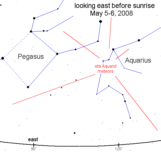
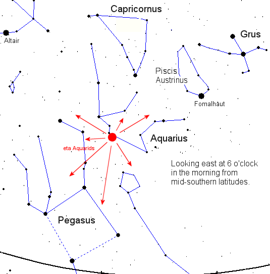