Friday, December 26, 2008
Flooding a concern: Flooding could be a problem through the day tomorrow especially by late day as we'll see showers and maybe even some thunderstorms which are in what we call the 'warm sector' of a weather system. This warm sector could produce temperatures in the 60s by tomorrow afternoon.
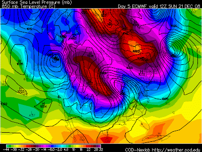
Arctic air for the new year: I wanted to show you something I've been following this week. First the GFS model picked it up and the model I like to call the King of Cold air the ECMWF is coming in with some cold air next week. It may not be as deep as the cold air we saw last weekend but it is certainly something to watch. Here is the start of it with that violet color moving in.
Temperatures by Thursday morning are -10 to -16 Celsius that could be really cold to begin the new year.
Wednesday, December 24, 2008
Tuesday, December 23, 2008
Monday, December 22, 2008
*Can be shallow or deep: most intense at the surface (due to cold/dense air) and weaken with height if away from source region. The upper levels will show a deep trough if the polar air mass moves into mid-latitudes. Cold core highs are deep near their source regions*Precipitation generally lacking near cold core high center*Covers a large spatial area*Produces synoptic scale surface subsidence*Develop over high latitude land.
So basically the cold polar air gets trapped at the surface while the warmer air which has a lower density and pressure rides above it, making for a dome which sits across the area.
Some relief?
Friday, December 19, 2008
More Pictures of the ice storm
Pictures of the ice
Getting Slick Out There!
Going to get worse
Just starting here
1AM Update
Thursday, December 18, 2008
Here is the breakdown right now. There is an Ice Storm Warning from Fort Wayne and to the south and a Winter Storm Warning north of Fort Wayne. It looks like the hours between 10pm tonight and 9am tomorrow morning will be touch and go especially south of Fort Wayne. Temperatures are going to be the biggest problem. Temperatures will get above freezing by about mid morning tomorrow, but before that is when areas from Fort Wayne south could see ice accumulation.
North of Fort Wayne: North of Fort Wayne could see some ice accumulation but more than likely the closer you get to the border of Michigan the more the ice will turn to snow. Around Steuben county we could see 3 to 4 inches of snow before morning. Usually the heaviest snow is just north of the ice storm. This situation will evolve over night and I'll try to blog out the storm for you.
The Weekend: Another winter storm will head our way. This one is coming from the south but will essentially open up that gateway to the Arctic Circle again.
Here is a look at the storm tomorrow afternoon. It is sitting across Texas. This storm will bring moisture our way on Sunday. One thing I'm not crazy about is the track of this low. It looks too far north to bring heavy snow to our area. However, it could bring some snow in front of the system, (what I like to call on-slaught snow). It is also going to bring very cold temperatures into Monday.
A White Christmas? Yes Virginia Santa is going to bring a white Christmas.
Here is Monday, ouch this is cold we'll be lucky to see temperatures in the teens this day and we could go sub zero for the first time as well.
Here is Christmas eve morning, it looks like another southern system will bring some light snow. Once again, I'm not thrilled with the track for heavy snow, but I'm sure will see some fresh snow on the ground.
Wednesday, December 17, 2008
A rough Thursday night and Friday morning?
Low pressure is making it's way northward by Thursday night and Friday morning. Most of the time that means warmer air for us. But this is kind of a complicated pattern as warm air will override the cold air at first and this is a set up for freezing rain.
Here's a couple of diagrams to explain this:
The pink represents snow on this diagram with the blue the warmer middle atmosphere. As the snow falls it melts in this middle atmosphere and then falls as rain (the green). As this liquid touches the freezing surface it freezes on impact and that's what the definition of freezing rain is. Many people think freezing rain is what is know as ice pellets or sleet.
Here is a temperature profile as the snow melts then falls into a freezing layer and because rain is not pure water, (it's actually a solution of dust and water) it doesn't freeze in the lower atmosphere and stays liquid until it hits a freezing surface then turns to ice.
It looks like freezing rain will be short lived as temperatures will rise into the 40s by Friday morning. They will quickly fall by Friday afternoon and the rain will change to snow.
The Weekend:
Another blast of colder air will bring temperatures into the 20s again but in the process to opening the gateway of cold air from the Arctic Circle. Southern moisture is coming in Sunday with a system moving across the plains by afternoon. It will quickly move across our area by Sunday evening. As far as heavy snowfall, this track is going to limit very heavy snowfall but it will turn bitterly cold.
You can see the bitter cold air coming in by Monday morning with 850 mb temperatures at -16 Celsius.
Tuesday, December 16, 2008
This model shows that the track of the low is through the southern part of the state and it looks like it will be far enough north to get some snow in northeastern Indiana. Interestingly enough one of the numerical output models I use has about a half an inch of snow. So it looks like this one is going to be close with most of the snow to the south.
As the week goes on: It should be rather quiet through mostly of the rest of the week, but Friday is a different story.
This the situation on Friday. Warm air ahead of a weather system has highs near +9 that could translate to about 49 degrees on the surface. So it will begin as rain on Friday, but much like the last system that moved through the area yesterday there is some cold air and we could be seeing snow by Friday night.
You can see another southern system moving north, but this time temperatures will be cold enough for some accumulating snowfall.
Then it gets very cold as bitter cold arctic air brings 850 mb down to -17 C. This will mean teens and 20s as highs to begin the week next week.
Monday, December 15, 2008
I want you to look at two things here. One is the low pressure and the lines around it called isobars. See how close they are together? That tells us that we are going to see gusty winds across the area today. The other thing is that bright red color across the plains. This low pressure has opened the gateway to the arctic circle and we have the core of the coldest air being felt over the plains this afternoon. Temperatures will fall well below zero through tomorrow.
Tuesday Storm System: Watch this storm system across the south it is moving rapidly towards us and will be here on Tuesday night.
Here is Wednesday morning. As the storm comes in Tuesday night we could see the mid levels of the atmosphere warm up while the surface stays at freezing. This is what freezing rain is all about as liquid sticks to an already frozen surface.
The rest of the week.
Highs will actually be around normal through Thursday with another storm coming our way on Friday. This is where is begins to get interesting.
Another southern weather system comes into the picture. It looks like rain and temperatures in the upper 40s again but we will see a drop by late afternoon. (Much like today).
Sunday looks very interesting as the cold air which will spend the week in the plains will finally make it way toward our area. Temperatures will only be in the 20s through the afternoon.
Friday, December 12, 2008
The weekend: A large scale weather system is still on track to move into our area by late Sunday.
You can see the warmer air still ahead of this system with temperatures in the 40s and 50s. Also some very breezy conditions as those isobars are tightly packed together here. By early Monday this system is pushed north but does it's job by opening the gateway to colder air from the north by late in the day. You can see the core of the coldest air dumping across the plains.
Fortunately the coldest air retreats and we are going to see moderately colder air across the region.
Thursday, December 11, 2008
You can see the colder air get dragged down to the south. The core of the coldest air, (the red color) shows the extremely cold air is not far away.
Interesting start next week: A huge weather system is moving through the plains early Sunday with some warmer air ahead of it. Take a look at how closely the isobars are packed together. This what is called a 'tight gradient' in meteorological terms. It means there is a big change in pressure and it is a red flag for the forecaster that there will be some gusty winds. The slope becomes pretty steep ahead of this weather system as cold air is allowed to dump into the plains while the warmer air gets forced into the Great Lakes area.
Moderately cold air moves into the area by late Monday and into Tuesday.
Wednesday, December 10, 2008
Quiet for a couple of days: A couple of things to point out here. A big weather system in the southeast will rob the moisture from a small clipper type system moving to our north. Not going to rob the cold air though as temperatures. That cold air will be felt on Friday as you can see we get the -12 Celsius line across the area by early Friday morning.
Warm and wet weekend? A large pacific system moves in by Monday. You can see temperatures are way up as the +8 line is well across our area. So that means rain and warmer temperatures.
Still warm ahead of the weather system but you can see the cold air is on the way and it looks like this next warm up is also going to be short lived.