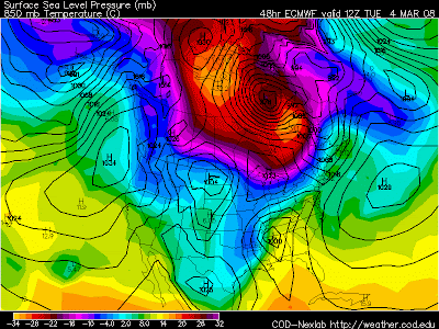
 We'll begin with the European model with the northern stream system coming through today. You can see the very mild air across the region but keep your eyes on the system across Texas.
 Now the northeast track begins. You might remember that last weeks system was coming across the boot hill of Missouri. This one comes across Tennessee.
 By 7am Wednesday this weather system heads towards Cleveland. This is a positive snow track for our area right now just a quick glance at this and the qpf tells me 4 to 6" is a good initial call.
 Now the Global Forecasting Model 1am Tuesday has the low across Louisiana and a secondary low across northern Kentucky. But the main low is south.
 By 7am Tuesday the low is in almost in the exact same place as the European. This is good news to actually have consensus in models this early in the game.
  Here is the 1pm Tuesday snap shot. The GFS actually slows the system down a bit, but also keeps it on a similar track as the European.
 Finally the last snap shot at 7pm Tuesday takes the system a little farther south then the European. However, keep in mind the tendency this Winter for every storm to take a more northwesterly track.

No comments:
Post a Comment